IMAGES TAKEN NEAR TO
Lineholt Lane, DROITWICH, WR9 0JU
Introduction
This page details the photographs taken nearby to Lineholt Lane, WR9 0JU by members of the Geograph project.
The Geograph project started in 2005 with the aim of publishing, organising and preserving representative images for every square kilometre of Great Britain, Ireland and the Isle of Man.

There are currently over 7.5m images from over14,400 individuals and you can help contribute to the project by visiting https://www.geograph.org.uk
Image Map
Images are licensed for reuse under creativecommons.org/licenses/by-sa/2.0
Notes
- Clicking on the map will re-center to the selected point.
- The higher the marker number, the further away the image location is from the centre of the postcode.
Image Listing (8 Images Found)
Images are licensed for reuse under creativecommons.org/licenses/by-sa/2.0
Image
Details
Distance
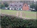
2
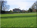
Woodfield House
A house with a splendid view across Worcestershire, seen from the public footpath across the park.
Image: © David Stowell
Taken: 1 Jan 2007
0.12 miles
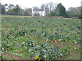
3
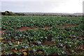
A field of cabbages
A field of cabbages near the village of Northampton.
Image: © Philip Halling
Taken: 27 Oct 2013
0.13 miles
4
Vegetable fields at Northampton, 1
Some purple-sprouting broccoli approaching the end of production.
Image: © Jonathan Billinger
Taken: 6 Mar 2019
0.13 miles
5
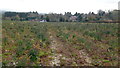
Vegetable fields at Northampton, 2
Some purple-sprouting broccoli approaching the end of production.
Looking south towards Uphampton.
Image: © Jonathan Billinger
Taken: 6 Mar 2019
0.14 miles
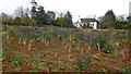
7
Woodfield Cottage, Northampton viewed over a field of Broccoli
Image: © Jeff Gogarty
Taken: 6 Jan 2019
0.20 miles
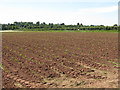
8
Woodfield Farm, Northampton over sloping field
Image: © Jeff Gogarty
Taken: 6 Jan 2019
0.21 miles