IMAGES TAKEN NEAR TO
Oldfield Lane, DROITWICH, WR9 0JL
Introduction
This page details the photographs taken nearby to Oldfield Lane, WR9 0JL by members of the Geograph project.
The Geograph project started in 2005 with the aim of publishing, organising and preserving representative images for every square kilometre of Great Britain, Ireland and the Isle of Man.

There are currently over 7.5m images from over14,400 individuals and you can help contribute to the project by visiting https://www.geograph.org.uk
Image Map
Images are licensed for reuse under creativecommons.org/licenses/by-sa/2.0
Notes
- Clicking on the map will re-center to the selected point.
- The higher the marker number, the further away the image location is from the centre of the postcode.
Image Listing (19 Images Found)
Images are licensed for reuse under creativecommons.org/licenses/by-sa/2.0
Image
Details
Distance
1
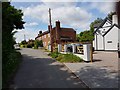
House on Oldfield Lane, near Ombersley
Image: © Jeff Gogarty
Taken: 17 May 2020
0.07 miles
4
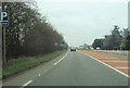
Uphampton turn off at Oldfield
From A449 south
Image: © John Firth
Taken: 16 Mar 2012
0.11 miles
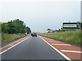
5
Cyclist on the A449 at Oldfield, near Ombersley
Image: © Jeff Gogarty
Taken: 17 May 2020
0.12 miles
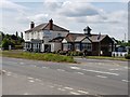
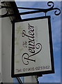
7
The Reindeer pub, Oldfield
A suitably seasonal name for a roadside hostelry.
Image: © Jeremy Bolwell
Taken: 22 Jan 2013
0.13 miles
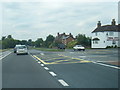
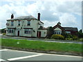
8
The Reindeer public house
On the A449 at Oldfield.
Image: © Ian S
Taken: 26 May 2014
0.13 miles
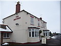
9
The Reindeer public house
On the A449 at Oldfield.
Image: © Ian S
Taken: 26 May 2014
0.13 miles
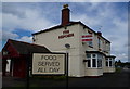
10
The Reindeer public house
On the A449 at Oldfield.
Image: © Ian S
Taken: 26 May 2014
0.13 miles