IMAGES TAKEN NEAR TO
Parsonage Lane, DROITWICH, WR9 0HP
Introduction
This page details the photographs taken nearby to Parsonage Lane, WR9 0HP by members of the Geograph project.
The Geograph project started in 2005 with the aim of publishing, organising and preserving representative images for every square kilometre of Great Britain, Ireland and the Isle of Man.

There are currently over 7.5m images from over14,400 individuals and you can help contribute to the project by visiting https://www.geograph.org.uk
Image Map
Images are licensed for reuse under creativecommons.org/licenses/by-sa/2.0
Notes
- Clicking on the map will re-center to the selected point.
- The higher the marker number, the further away the image location is from the centre of the postcode.
Image Listing (10 Images Found)
Images are licensed for reuse under creativecommons.org/licenses/by-sa/2.0
Image
Details
Distance
1
Field boundary near Uphampton, Worcestershire
Image: © Jeff Gogarty
Taken: 25 Nov 2021
0.15 miles
2
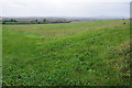
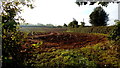
Farmland at Uphampton
View over the Severn valley to the west of Uphampton, the hills at Abberley are just visible to the right.
Image: © Philip Halling
Taken: 27 Oct 2013
0.16 miles
3
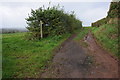
Track and footpath, Uphampton
Track and footpath across farmland to the west of Uphampton.
Image: © Philip Halling
Taken: 27 Oct 2013
0.16 miles
4
Fields next to a footpath, near to Uphampton
Image: © Jeff Gogarty
Taken: 25 Nov 2021
0.18 miles
5
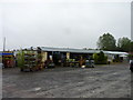
The Farm Shop, Knottsfield Nurseries, Ombersley
The shop is on Holt Fleet Road. It is much more extensive inside than you would image from the outside view.
Image: © Jeff Gogarty
Taken: 31 Aug 2015
0.19 miles
6
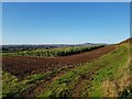
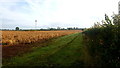
Recently-drilled crop
Arable land by Boreley Lane.
Image: © Jonathan Billinger
Taken: 18 Sep 2017
0.22 miles
7
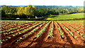
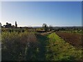
Vegetable crop
The field of brassicas (can't tell which) is on fertile ground on the eastern slope of the Severn valley between Ombersley and Holt Fleet.
Early morning traffic on the A443 can be seen.
Image: © Jonathan Billinger
Taken: 18 Sep 2017
0.23 miles
8
Arable crop
The residue of a crop by Boreley Lane; could be field beans.
Image: © Jonathan Billinger
Taken: 18 Sep 2017
0.23 miles
9
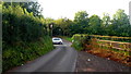
Boreley Lane
Looking south towards the junction with the A443.
Image: © Jonathan Billinger
Taken: 18 Sep 2017
0.24 miles
10
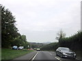
Minor Crossroad on A4133 Near Holt Fleet
Image: © Roy Hughes
Taken: 2 Oct 2014
0.25 miles