IMAGES TAKEN NEAR TO
Old Chawson Lane, DROITWICH, WR9 0AQ
Introduction
This page details the photographs taken nearby to Old Chawson Lane, WR9 0AQ by members of the Geograph project.
The Geograph project started in 2005 with the aim of publishing, organising and preserving representative images for every square kilometre of Great Britain, Ireland and the Isle of Man.

There are currently over 7.5m images from over14,400 individuals and you can help contribute to the project by visiting https://www.geograph.org.uk
Image Map
Images are licensed for reuse under creativecommons.org/licenses/by-sa/2.0
Notes
- Clicking on the map will re-center to the selected point.
- The higher the marker number, the further away the image location is from the centre of the postcode.
Image Listing (59 Images Found)
Images are licensed for reuse under creativecommons.org/licenses/by-sa/2.0
Image
Details
Distance
1

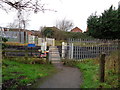
Old Chawson Lane, Droitwich
Chawson Valley is on the south-western edge of Droitwich.
Image: © Jeff Gogarty
Taken: 21 Jun 2015
0.04 miles
2

Chawson Barn Community Centre
Chawson Barn is a community run hall, situated on New Chawson Lane, Droitwich The Barn has various user groups that offer a variety of activities. It can hold up to 110 people.
Photo taken from Old Chawson Lane.
Image: © Jeff Gogarty
Taken: 21 Jun 2015
0.05 miles
3
Chawson Crossing, Droitwich, Worcestershire
This crossing is at the end of Colford Walk Image There are flowers as another person has recently been killed crossing here.
Image: © Jeff Gogarty
Taken: 1 Jan 2016
0.08 miles

5
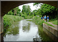
Droitwich Barge Canal near Droitwich Spa, Worcestershire
This is the canal looking south-west from the western edge of the town.
Image: © Roger D Kidd
Taken: 23 Jun 2013
0.11 miles
6
Droitwich Canal
The Droitwich canal viewed from the Ombersley Way bridge. The canal connected Droitwich with the river Severn to the north of Worcester and is one of the oldest, designed by James Brindley and opened in March 1771. Today the canal is not fully navigable as it is no longer connected to the Severn. See: http://www.worcs.com/dct/newfront.htm
Image: © Philip Halling
Taken: 11 Mar 2006
0.11 miles
7
Ombersley Way crossing the Droitwich Canal
Image: © David Howard
Taken: 9 Feb 2019
0.11 miles
8
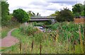
Droitwich Barge Canal - Ombersley Way Bridge
The canal is now open, after many decades of closure. It is crossed here by Ombersley Way.
Image: © P L Chadwick
Taken: 10 Sep 2011
0.12 miles
9

Bus shelter in Ombersley Way, Droitwich
Beyond the bus shelter there are houses in a new estate, many in cul-de-sacs
Image: © David Smith
Taken: 20 May 2013
0.12 miles
10

Bridge No 9 near Chawson, Worcestershire
The bridge carries Ombersley Way.
Image: © Roger D Kidd
Taken: 21 Jun 2013
0.12 miles