IMAGES TAKEN NEAR TO
Longdon Heath, WORCESTER, WR8 0RJ
Introduction
This page details the photographs taken nearby to Longdon Heath, WR8 0RJ by members of the Geograph project.
The Geograph project started in 2005 with the aim of publishing, organising and preserving representative images for every square kilometre of Great Britain, Ireland and the Isle of Man.

There are currently over 7.5m images from over14,400 individuals and you can help contribute to the project by visiting https://www.geograph.org.uk
Image Map
Images are licensed for reuse under creativecommons.org/licenses/by-sa/2.0
Notes
- Clicking on the map will re-center to the selected point.
- The higher the marker number, the further away the image location is from the centre of the postcode.
Image Listing (10 Images Found)
Images are licensed for reuse under creativecommons.org/licenses/by-sa/2.0
Image
Details
Distance
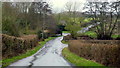
1
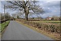
Country road at Longdon Heath
Country road passing the Reddings at Longdon Heath.
Image: © Philip Halling
Taken: 26 Feb 2018
0.03 miles
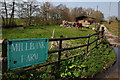
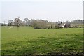
4
Track to Mill Bank Farm
Mill Brook flows to the left.
Image: © Jonathan Billinger
Taken: 28 Dec 2012
0.07 miles
5
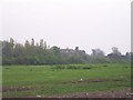
Eastington Hall & Deserted Mediaeval Village
The hall now hidden behind a modern screen of trees is on the site of the DMV of Eastington - surveyed by the South Worcs Archaeological Group
Image: © Bob Embleton
Taken: 25 Apr 2005
0.08 miles
6

Pink dawn over Worcestershire
The poplar trees lining the road to Eastington Hall stand out against the dawn-time valley mists.
Viewed from Black Hill, on the Malverns, some 23 km away.
Eastington in Worcestershire was a medieval village until it was closed except for the hall which developed, possibly on the profits of the wool trade.
Much of the remains of the deserted medieval village and its ridge and furrow field system (recorded in the early 1980s) has disappeared with modern landscaping of the grounds including a new lake.
Image: © Bob Embleton
Taken: 22 Sep 2012
0.08 miles
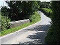
7
Lane to Longdon Hill
The lane crosses the Mill Brook between the two footpath fingerposts. The drive to the right leads to Mill Bank Farm.
Image: © Jonathan Billinger
Taken: 28 Dec 2012
0.08 miles
8
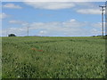
Interlopers
Amidst a sea of wheat, two wild flowers stand tall.
Image: © Peter Whatley
Taken: 10 Jun 2008
0.16 miles
9
Woodland Cottage
Down the dip next to the stream from the Stanks.
Image: © Bob Embleton
Taken: 4 Apr 2008
0.21 miles
10
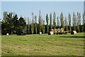
Loading bales of hay
The farmer is taking advantage of the Indian summer and made some late hay, here the tractor is loading round bale onto a trailer.
Image: © Philip Halling
Taken: 14 Sep 2020
0.22 miles