IMAGES TAKEN NEAR TO
Queenhill, WORCESTER, WR8 0RE
Introduction
This page details the photographs taken nearby to Queenhill, WR8 0RE by members of the Geograph project.
The Geograph project started in 2005 with the aim of publishing, organising and preserving representative images for every square kilometre of Great Britain, Ireland and the Isle of Man.

There are currently over 7.5m images from over14,400 individuals and you can help contribute to the project by visiting https://www.geograph.org.uk
Image Map
Images are licensed for reuse under creativecommons.org/licenses/by-sa/2.0
Notes
- Clicking on the map will re-center to the selected point.
- The higher the marker number, the further away the image location is from the centre of the postcode.
Image Listing (32 Images Found)
Images are licensed for reuse under creativecommons.org/licenses/by-sa/2.0
Image
Details
Distance
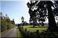
2
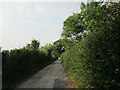
The road to Bredon School
Beginning of the private road (but public footpath) from Queenhill to Bredon School and several other properties. A delightful walk.
Image: © Peter Whatley
Taken: 10 Jun 2008
0.02 miles
3
Cedar Bank, Queenhill
According to a local history site, Cedar Bank was once the lodge to the great house.
http://www.visitoruk.com/historydetail.php?id=26807&f=Greatmalvern
Image: © Bob Embleton
Taken: 25 Apr 2005
0.02 miles
4
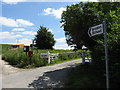
Queenhill corner
Looking north from the 90-degree curve where the public road meets the private road to Bredon School.
Image: © Peter Whatley
Taken: 10 Jun 2008
0.03 miles
5

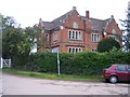
Timber-framed cottage
Trees have been cut down opening this timber-framed cottage to the passing road at Queenhill. The cottage is Grade II listed https://historicengland.org.uk/listing/the-list/list-entry/1273873 It dates from the 17th century and in the 19th century was altered into a School House.
Image: © Philip Halling
Taken: 30 Aug 2021
0.04 miles
7
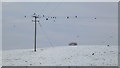
A murder of crows
These corvids are collecting on power lines on the snowy slope of Queenhill.
Image: © Jonathan Billinger
Taken: 24 Jan 2013
0.10 miles
9
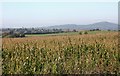
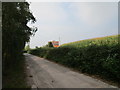
Maize crop at Queenhill
Taken from near the gates to Churchend Farm.
Looking towards the southern peaks of the Malvern Hills:
Chase End Hill and Ragged Stone Hill on the right.
Longdon with its church spire is on the left of the picture.
Image: © Bob Embleton
Taken: 17 Oct 2010
0.12 miles
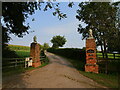
10
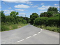
Lane to Queenhill church
Now designated as a private road with a strip of parkland on the right before the maize field.
Image: © Bob Embleton
Taken: 17 Oct 2010
0.14 miles