IMAGES TAKEN NEAR TO
Queenhill, WORCESTER, WR8 0RD
Introduction
This page details the photographs taken nearby to Queenhill, WR8 0RD by members of the Geograph project.
The Geograph project started in 2005 with the aim of publishing, organising and preserving representative images for every square kilometre of Great Britain, Ireland and the Isle of Man.

There are currently over 7.5m images from over14,400 individuals and you can help contribute to the project by visiting https://www.geograph.org.uk
Image Map
Images are licensed for reuse under creativecommons.org/licenses/by-sa/2.0
Notes
- Clicking on the map will re-center to the selected point.
- The higher the marker number, the further away the image location is from the centre of the postcode.
Image Listing (25 Images Found)
Images are licensed for reuse under creativecommons.org/licenses/by-sa/2.0
Image
Details
Distance
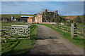
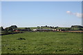
1
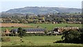
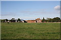
Farm buildings of Queenshill Manor
Looking down from Heath Hill to the farm land with Ripple church in the near distance and Bredon Hill in the far distance.
The 18th century tower atop the hill is called Parsons Folly.
The top of the tower is 1000 feet above sea level.
Image: © Bob Embleton
Taken: 17 Oct 2010
0.02 miles
2

Farmland near Queenshill Manor
Fields to the north of Queenshill Manor
Image: © Philip Halling
Taken: 5 Jun 2007
0.04 miles
3
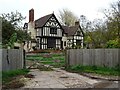
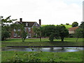
Queenhill Manor
Queenhill Manor dates from the late 16th and early 17th century. The building is Grade II listed; see https://historicengland.org.uk/listing/the-list/list-entry/1273872
Image: © Philip Halling
Taken: 1 Nov 2020
0.04 miles
5
Green Farm, Holdfast
Green Farm has a very impressive early 18th century farmhouse, viewed here from the entrance. The Queen Anne-style house is Grade II listed, see: https://historicengland.org.uk/listing/the-list/list-entry/1239104
Image: © Philip Halling
Taken: 2 Mar 2008
0.12 miles
6
Green Farm
Near the northern boundary of the parish of Queenhill.
The farm house has been described as "an elegant Georgian house"
The northerly peaks of the Malvern Hills range can be seen in the distance.
http://www.visitoruk.com/historydetail.php?id=26807&f=Greatmalvern
Image: © Bob Embleton
Taken: 17 Oct 2010
0.15 miles
8
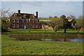
Green Farm, Holdfast
The farmhouse of Green Farm is an impressive early 18th century red brick house. The Queen Anne-style house is Grade II listed, see: https://historicengland.org.uk/listing/the-list/list-entry/1239104
Image: © Philip Halling
Taken: 2 Mar 2008
0.15 miles
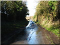
9
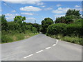
Queenhill corner
Looking north from the 90-degree curve where the public road meets the private road to Bredon School.
Image: © Peter Whatley
Taken: 10 Jun 2008
0.17 miles
10
Cow Pasture near Queenshill Manor
Looking over the fields towards the farm buildings of Queenshill Manor.
Image: © Bob Embleton
Taken: 17 Oct 2010
0.19 miles