IMAGES TAKEN NEAR TO
Tunnel Hill, WORCESTER, WR8 0QL
Introduction
This page details the photographs taken nearby to Tunnel Hill, WR8 0QL by members of the Geograph project.
The Geograph project started in 2005 with the aim of publishing, organising and preserving representative images for every square kilometre of Great Britain, Ireland and the Isle of Man.

There are currently over 7.5m images from over14,400 individuals and you can help contribute to the project by visiting https://www.geograph.org.uk
Image Map
Images are licensed for reuse under creativecommons.org/licenses/by-sa/2.0
Notes
- Clicking on the map will re-center to the selected point.
- The higher the marker number, the further away the image location is from the centre of the postcode.
Image Listing (53 Images Found)
Images are licensed for reuse under creativecommons.org/licenses/by-sa/2.0
Image
Details
Distance
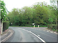
3
Tunnel Hill - the way west
Along the A4104 from the house at the B4211 junction.
Image: © Peter Whatley
Taken: 8 Jun 2008
0.02 miles
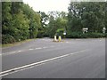
4
Tunnel Hill junction
The B4211 meets the A4104 near Upton-upon-Severn.
Image: © Peter Whatley
Taken: 8 Jun 2008
0.03 miles
5
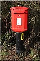
Letterbox at Tunnel Hill
A modern style letterbox beside the A4104 at Tunnel Hill just west of Upton-upon-Severn.
Image: © Philip Halling
Taken: 12 Feb 2018
0.04 miles
6
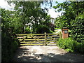
Tunnel Hill - May Cottage
One of the older properties at Tunnel Hill.
Image: © Peter Whatley
Taken: 8 Jun 2008
0.04 miles
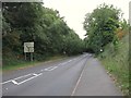
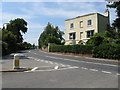
8
A4104 Welland Road at Tunnel Hill
Heading west.
Image: © J.Hannan-Briggs
Taken: 24 Feb 2017
0.09 miles
9
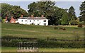
The Hill, Upton
Possibly built in the 1780s but considerably extended over the next two centuries.
In 1788 John Martin leased a "new built" house to his steward.
http://www.upton.uk.net/history/thehill/thehill.html
Image: © Bob Embleton
Taken: 27 Aug 2014
0.10 miles
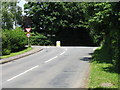
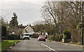
10
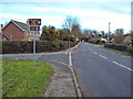
Road junction at Tunnel Hill
Looking east along the A4104 Welland Road. The road on the left is Greenfields, which leads to Clive's Fruit Farm and Tiltridge Vineyard a mile to the north.
Image: © Trevor Rickard
Taken: 4 Dec 2009
0.10 miles