IMAGES TAKEN NEAR TO
Minge Lane, WORCESTER, WR8 0LS
Introduction
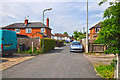
This page details the photographs taken nearby to Minge Lane, WR8 0LS by members of the Geograph project.
The Geograph project started in 2005 with the aim of publishing, organising and preserving representative images for every square kilometre of Great Britain, Ireland and the Isle of Man.

There are currently over 7.5m images from over14,400 individuals and you can help contribute to the project by visiting https://www.geograph.org.uk
Image Map (Loading...)


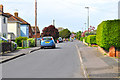
Getting Data...Please wait
Leaflet Map data © OpenStreetMap
Images are licensed for reuse under creativecommons.org/licenses/by-sa/2.0
Notes
- Clicking on the map will re-center to the selected point.
- The higher the marker number, the further away the image location is from the centre of the postcode.
Image Listing (284 Images Found)
Images are licensed for reuse under creativecommons.org/licenses/by-sa/2.0
Image
Details
Distance
1
Upton Upon Severn : Cherry Orchard
Cherry Orchard is a small cul-de-sac off of Minge Lane.
Image: © Lewis Clarke
Taken: 5 May 2014
0.02 miles
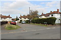
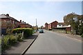
2

Cherry Orchard, Upton-upon-Severn
A 1920s social housing development between Minge Lane and the town's cemetery.
Image: © Bob Embleton
Taken: 23 Sep 2011
0.02 miles
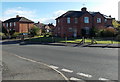
3
Urban Upton
Looking down Minge Lane from the junction with Rectory Road.
Image: © Peter Whatley
Taken: 8 Jun 2008
0.02 miles
4
Gardens Close, Upton-upon-Severn
A small development of semi-detached (probably council) houses.
I expect these date from the post WWI social housing boom of the 1920s.
Not built with car ownership in mind.
Image: © Bob Embleton
Taken: 23 Sep 2011
0.02 miles
5
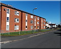
Edward Hall House, Upton-upon-Severn
Minge Lane side of 3-storey flats in School Road. See http://www.geograph.org.uk/photo/4421982 for notes about the name Minge Lane.
Image: © Jaggery
Taken: 3 Nov 2013
0.04 miles
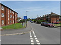
6
Upton Upon Severn : Gardens Walk
Looking along Gardens Walk in the residential suburbs of Upton Upon Severn.
Image: © Lewis Clarke
Taken: 5 May 2014
0.04 miles
7
Minge Lane, Upton
Looking west from the junction with Laburnum Walk.
1920s council houses on the left with more modern social housing on the right.
Image: © Bob Embleton
Taken: 22 Apr 2010
0.04 miles
8
Minge Lane houses, Upton-upon-Severn
From the corner of School Lane. In February 2014, the Daily Mirror listed Minge Lane in Upton-upon-Severn as number 1 in the top ten rudest street names in the country, based on the negative impact they have on house prices in the street compared with similar properties in nearby streets.
The Mirror's statement that names now seen as rude are because "town planners dream up daft names" is untrue in many cases, where the name may be of medieval origin. A local history source states that this Minge Lane is of at least early 19th century origin, perhaps earlier. The first recorded use of the vulgar meaning of the word is about a century later.
Image: © Jaggery
Taken: 3 Nov 2013
0.04 miles
9
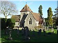
Cemetery chapel
Cemetery chapel, off Rectory Road in Upton-upon-Severn. The chapel was designed by architect G R Clarke who is buried in the cemetery.
Image: © Philip Halling
Taken: 27 Dec 2020
0.06 miles
10
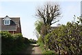
Track up from Upper Ham
The river Severn flood plain at Upton is known as Upper Ham.
This access lane climbs up onto the higher ground to become Minge Lane.
Image: © Bob Embleton
Taken: 22 Apr 2010
0.06 miles