IMAGES TAKEN NEAR TO
Perrins Field, WORCESTER, WR8 0ER
Introduction
This page details the photographs taken nearby to Perrins Field, WR8 0ER by members of the Geograph project.
The Geograph project started in 2005 with the aim of publishing, organising and preserving representative images for every square kilometre of Great Britain, Ireland and the Isle of Man.

There are currently over 7.5m images from over14,400 individuals and you can help contribute to the project by visiting https://www.geograph.org.uk
Image Map (Loading...)


Getting Data...Please wait
Leaflet Map data © OpenStreetMap
Images are licensed for reuse under creativecommons.org/licenses/by-sa/2.0
Notes
- Clicking on the map will re-center to the selected point.
- The higher the marker number, the further away the image location is from the centre of the postcode.
Image Listing (48 Images Found)
Images are licensed for reuse under creativecommons.org/licenses/by-sa/2.0
Image
Details
Distance
1
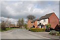
Milestone Road, Tunnel Hill
A relatively new housing estate off the Welland Road after the Hill School had closed.
Image: © Bob Embleton
Taken: 4 Apr 2008
0.02 miles
2
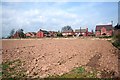
New Houses on the Welland Road
Houses extending the tunnel Hill area of Upton towards the old school site. How soon before this field succumbs to the pressure of housing? Taken from the awkwardly ploughed up footpath to Monsell Lane.
Image: © Bob Embleton
Taken: 4 Apr 2008
0.06 miles
3

The Hill Centre
A community centre formed from the remains of the Hill School.
Image: © Bob Embleton
Taken: 4 Apr 2008
0.06 miles
4
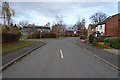
Milestone Road, Tunnel Hill
Housing estate at Tunnel Hill off the A4104. The Upton Hill Community Centre can be seen on the left.
Image: © Philip Halling
Taken: 25 Nov 2018
0.07 miles
5
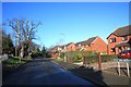
Hyde Lane, Tunnel Hill, Upton
A small development of seven detached houses. There was room for an eighth, but this may have been kept free to provide access to a future development.
Image: © Bob Embleton
Taken: 18 Jan 2009
0.08 miles
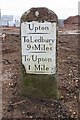
6
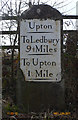
Old Milestone by the A4104, Tunnel Hill, Upton upon Severn
Metal plate attached to stone post by the A4104, in parish of UPTON UPON SEVERN (MALVERN HILLS District), The Hyde, 25m East of Milestone Road, Tunnel Hill, on the verge, on South side of road. Upton iron plate, erected by the Upton-upon-Severn turnpike trust in the 19th century.
Inscription reads:-
UPTON
----
To Ledbury
9½ Miles
----
To Upton
1 Mile
----
Grade II listed.
List Entry Number: 1227339 https://historicengland.org.uk/listing/the-list/list-entry/1227339
Milestone Society National ID: WO_USLB01.
Image: © J Higgins
Taken: 2 Nov 2008
0.09 miles
7
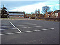
Tunnel Hill Community Centre car park
Looking north across the large car park to the community centre building. Houses of Milestone Road on the right.
Image: © Trevor Rickard
Taken: 4 Dec 2009
0.09 miles
8
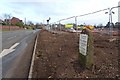
Milestone at Tunnel Hill
Milestone at Tunnel Hill beside the A4104. Until a few days ago this milestone was barely visible in a hedgerow, the hedge has been grubbed out in the last few days in preparation for building.
Image: © Philip Halling
Taken: 25 Nov 2018
0.09 miles
9
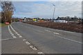
The A4104 at Tunnel Hill
The A4104 at Tunnel Hill. Until last week there was a hedge on the other side of the road, that has been grubbed out in preparation for the building of houses.
Image: © Philip Halling
Taken: 25 Nov 2018
0.09 miles
10
Milestone at Tunnel Hill
Until a few days ago this milestone was only just visible in a hedge, as can be seen in the background this is a site being prepared for building and the roadside hedge has been grubbed out.
Image: © Philip Halling
Taken: 25 Nov 2018
0.09 miles