IMAGES TAKEN NEAR TO
Cherry Blossom Close, WORCESTER, WR8 0AF
Introduction
This page details the photographs taken nearby to Cherry Blossom Close, WR8 0AF by members of the Geograph project.
The Geograph project started in 2005 with the aim of publishing, organising and preserving representative images for every square kilometre of Great Britain, Ireland and the Isle of Man.

There are currently over 7.5m images from over14,400 individuals and you can help contribute to the project by visiting https://www.geograph.org.uk
Image Map
Images are licensed for reuse under creativecommons.org/licenses/by-sa/2.0
Notes
- Clicking on the map will re-center to the selected point.
- The higher the marker number, the further away the image location is from the centre of the postcode.
Image Listing (146 Images Found)
Images are licensed for reuse under creativecommons.org/licenses/by-sa/2.0
Image
Details
Distance
1
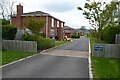
Cherry Blossom Close
Cherry Blossom Close, a recent housing development in Hanley Swan.
Image: © Philip Halling
Taken: 22 Apr 2022
0.02 miles
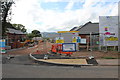
2
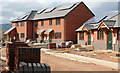
Building site (right), Hanley Swan
On the Welland road on what was a meadow between the school and the limit of residential land.
Note the photo-voltaic solar panels already fitted to the south facing roofs.
Image]
Image]
Image]
Image: © Bob Embleton
Taken: 10 Sep 2011
0.03 miles
3
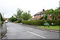
Westmere, Hanley Swan
Late 1960s development, probably engulfing one field's worth of pasture in the village.
Image: © Bob Embleton
Taken: 16 May 2007
0.04 miles
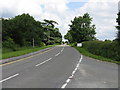
4
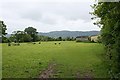
Horse Jumps in Meadow
Located off the Welland Road between the school and the residential area.
Image: © Bob Embleton
Taken: 16 May 2007
0.04 miles
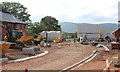
5
Housing development, Hanley Swan
On the Welland road on what was a meadow between the school and the limit of residential land.
There will be 11 new homes for rent or "HomeBuy":
4 three bedroomed houses, 3 two bedroomed houses,
2 two bedroomed bungalows and 2 two bedroomed apartments.
Under the "HomeBuy" scheme the occupier initially buys between 25% and 75% of the house with the option of buying more shares in the house later.
http://www.homebuy.org.uk/homebuy_schemes.html
How the meadow looked in 2007:
Image]
Image]
Image]
Image]
Image: © Bob Embleton
Taken: 10 Sep 2011
0.05 miles
6
Building site (centre), Hanley Swan
On the Welland road on what was a meadow between the school and the limit of residential land.
How the meadow looked in 2007:
Image]
Image]
Image]
Image]
Image: © Bob Embleton
Taken: 10 Sep 2011
0.05 miles
8
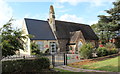
Hanley Swan C of E primary school
A Church of England "controlled" school on the Welland Road next to the village hall.
It was built around 1861 as a "school for the education of children and adults or children only of the Labouring, Manufacturing or other poorer classes."
In 1947 it became solely a primary school.
Notice how the older part of the school, with Malvern granite walls, looks just like a chapel - for indeed it was also used as a chapel of ease for the inhabitants of the Swan Green area (now called Hanley Swan) until St Gabriel's church was built.
Image: © Bob Embleton
Taken: 10 Sep 2011
0.08 miles
9
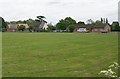
Hanley Swan Village School and Memorial Hall
Looking across the playing field from the bridleway to Merebrook Farm.
Image: © Bob Embleton
Taken: 16 May 2007
0.09 miles
10
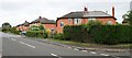
Council Houses, Hanley Swan
Probably built between the wars as agricultural workers cottages. Located on the Welland Road between Picken End road (to the right) and The Ewe & Lamb pub to the left. Large gardens, but no garages. Many will have been bought up and sold on as private houses.
Image: © Bob Embleton
Taken: 16 May 2007
0.10 miles