IMAGES TAKEN NEAR TO
Holt Heath, WORCESTER, WR6 6NN
Introduction
This page details the photographs taken nearby to WR6 6NN by members of the Geograph project.
The Geograph project started in 2005 with the aim of publishing, organising and preserving representative images for every square kilometre of Great Britain, Ireland and the Isle of Man.

There are currently over 7.5m images from over14,400 individuals and you can help contribute to the project by visiting https://www.geograph.org.uk
Image Map
Images are licensed for reuse under creativecommons.org/licenses/by-sa/2.0
Notes
- Clicking on the map will re-center to the selected point.
- The higher the marker number, the further away the image location is from the centre of the postcode.
Image Listing (68 Images Found)
Images are licensed for reuse under creativecommons.org/licenses/by-sa/2.0
Image
Details
Distance
1
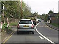
Queuing for the roadworks
A very long queue is usual on all roads around Ombersley due to longstanding roadworks. The lane just visible on the left offers locals a somewhat tortuous escape route - provided you can remember all the twists and turns!
Image: © Peter Whatley
Taken: 26 Oct 2011
0.01 miles
2
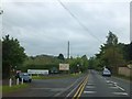
Business advertising in Holt Fleet
The entrance to the caravan site also serves as a site for adverts for Fisheries, an inn, and (temporarily) a car sale.
Image: © David Smith
Taken: 20 May 2013
0.03 miles
4
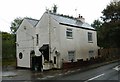
Old Toll House by the A4133, Holt Fleet
Holt Fleet Toll House by the A4133, in parish of Ombersley (Wychavon District), Letterbox Cottage, Ombersley Road, junction with Holt Fleet lane.
Worcestershire and Worcester City HER.
HER Reference: WSM22950 https://www.heritagegateway.org.uk/Gateway/Results_Single.aspx?uid=MWR13872&resourceID=1035
Surveyed
Milestone Society National ID: WO.OMB02
Image: © Alan Rosevear
Taken: 4 Oct 2014
0.07 miles
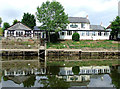
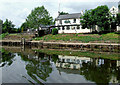
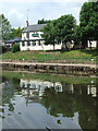
5
Houses at Holt Fleet from the riverside path (1)
Image: © Jeff Gogarty
Taken: 25 Nov 2021
0.10 miles
6
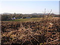
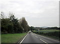
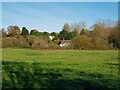
Rhubarb field
This view looks across to Abberley Hill which forms the skyline, with Woodbury Hill on the left. The crop in the field is rhubarb which gave off a very strong scent.
Image: © Richard Greenwood
Taken: 6 Dec 2008
0.11 miles
7
The Wharf Inn at Holt Fleet, Worcestershire
There are plenty of visitor moorings here, but only one small vessel (off to the left) taking advantage of them. This public house on the bank of the River Severn is liable to flooding.
See Image]
Image: © Roger D Kidd
Taken: 21 Jun 2013
0.13 miles
8
The Wharf Inn at Holt Fleet, Worcestershire
There are plenty of visitor moorings here, but only one small vessel (just out of sight) taking advantage of them. This public house on the bank of the River Severn is liable to flooding.
Image: © Roger D Kidd
Taken: 21 Jun 2013
0.13 miles
9
The Wharf Inn at Holt Fleet, Worcestershire
There are plenty of visitor moorings here, but only one small vessel taking advantage of them. This public house on the bank of the River Severn is liable to flooding.
Image: © Roger D Kidd
Taken: 21 Jun 2013
0.13 miles
10
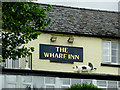
The Wharf Inn (detail) at Holt Fleet, Worcestershire
There are four farm animals grazing on the flat roof below the pub sign board Old Spot, the pig, doesn't actually have a satellite dish plugged into his bottom.
See also: Image]
Image: © Roger D Kidd
Taken: 23 Jun 2013
0.13 miles