IMAGES TAKEN NEAR TO
Clifton-on-Teme, WORCESTER, WR6 6EG
Introduction
This page details the photographs taken nearby to WR6 6EG by members of the Geograph project.
The Geograph project started in 2005 with the aim of publishing, organising and preserving representative images for every square kilometre of Great Britain, Ireland and the Isle of Man.

There are currently over 7.5m images from over14,400 individuals and you can help contribute to the project by visiting https://www.geograph.org.uk
Image Map
Images are licensed for reuse under creativecommons.org/licenses/by-sa/2.0
Notes
- Clicking on the map will re-center to the selected point.
- The higher the marker number, the further away the image location is from the centre of the postcode.
Image Listing (10 Images Found)
Images are licensed for reuse under creativecommons.org/licenses/by-sa/2.0
Image
Details
Distance
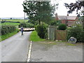
1
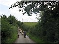
Driving the sheep
Almost at the end of a mile-long drove into the valley from Oxhall Farm.
Image: © Peter Whatley
Taken: 11 Sep 2008
0.06 miles
2
Sheep near Lamb Green
Sheep near Lamb Green to the east of Tedstone Delamere.
Image: © Philip Halling
Taken: 19 Aug 2012
0.07 miles
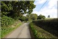
3
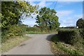
Lamb Green
A lane south of Clifton upon Teme.
Image: © Richard Webb
Taken: 19 Oct 2016
0.08 miles
6
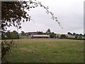
Thrift Farm
Viewed from the south west.
Image: © Bob Embleton
Taken: 5 Oct 2005
0.17 miles
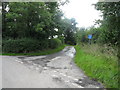
8
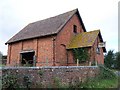
Barn Chapel
Surely this must have been a non-conformist chapel (or perhaps a school room) long converted to a barn. at the junction of the no through road to Primrose Hill.
Image: © Bob Embleton
Taken: 30 Sep 2005
0.21 miles
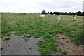
9
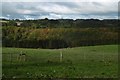
Herefords by Thrift Coppice
A herd in the far eastern reaches of the county.
Image: © Richard Webb
Taken: 19 Oct 2016
0.21 miles
10
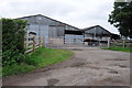
Thrift Farm
Farm buildings at Thrift Farm near Tedstone Delamere.
Image: © Philip Halling
Taken: 19 Aug 2012
0.23 miles