IMAGES TAKEN NEAR TO
Dormouse Croft, WORCESTER, WR5 3TT
Introduction
This page details the photographs taken nearby to Dormouse Croft, WR5 3TT by members of the Geograph project.
The Geograph project started in 2005 with the aim of publishing, organising and preserving representative images for every square kilometre of Great Britain, Ireland and the Isle of Man.

There are currently over 7.5m images from over14,400 individuals and you can help contribute to the project by visiting https://www.geograph.org.uk
Image Map
Images are licensed for reuse under creativecommons.org/licenses/by-sa/2.0
Notes
- Clicking on the map will re-center to the selected point.
- The higher the marker number, the further away the image location is from the centre of the postcode.
Image Listing (86 Images Found)
Images are licensed for reuse under creativecommons.org/licenses/by-sa/2.0
Image
Details
Distance
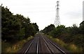
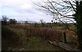
2
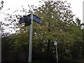
Signs ready but obscured
Even the council is ready for the bridleway to be completed.
Image: © Andrew Darge
Taken: 1 Nov 2019
0.05 miles
3
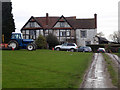
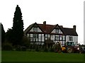
Upper Battenhall Farm
Seen from the public footpath across the property that at this point runs down the access road.
Image: © Chris Allen
Taken: 8 Jan 2020
0.07 miles
4
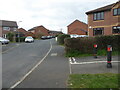
Deer Avenue, St Peter The Great
A path and cycleway crosses the road at this point.
Image: © Chris Allen
Taken: 21 Mar 2021
0.08 miles
5
Upper Battenhall Farm
Surrounded by roads and the railway this is the last of the three farms originating from the ancient manor of Battenhall where Elizabeth I was reputed to have hunted on her progress to Worcester (the faithful city).
Image: © Andrew Darge
Taken: 14 Mar 2009
0.09 miles
6
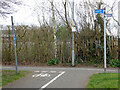
Junction of path and cycleway, St Peter The Great
On the edge of the housing development with the railway line behind the fence. Battenhall is to the left and Norton to the right via a new footbridge.
Image: © Chris Allen
Taken: 21 Mar 2021
0.09 miles
7
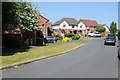
Grasshopper Avenue, St Peter's
St Peter's is a 1980s housing development on the southern edge of the city.
Image: © Philip Halling
Taken: 15 May 2018
0.09 miles
8
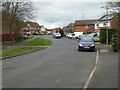
Grasshopper Avenue, St Peter The Great
A public right of way and cycleway crosses the road ahead of the photographer. St Peter The Great is a large modern housing development on the edge of Worcester.
Image: © Chris Allen
Taken: 21 Mar 2021
0.09 miles
9
Malvern view from MEB hut
A view of the Malverns from beside the old MEB training school hut.
Image: © Andrew Darge
Taken: 14 Mar 2009
0.09 miles
10
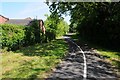
Cycleway and path in St Peter's
Cycleway and path passing through the St Peter's housing estate.
Image: © Philip Halling
Taken: 15 May 2018
0.10 miles