IMAGES TAKEN NEAR TO
Slimbridge Close, WORCESTER, WR5 3SH
Introduction
This page details the photographs taken nearby to Slimbridge Close, WR5 3SH by members of the Geograph project.
The Geograph project started in 2005 with the aim of publishing, organising and preserving representative images for every square kilometre of Great Britain, Ireland and the Isle of Man.

There are currently over 7.5m images from over14,400 individuals and you can help contribute to the project by visiting https://www.geograph.org.uk
Image Map
Images are licensed for reuse under creativecommons.org/licenses/by-sa/2.0
Notes
- Clicking on the map will re-center to the selected point.
- The higher the marker number, the further away the image location is from the centre of the postcode.
Image Listing (161 Images Found)
Images are licensed for reuse under creativecommons.org/licenses/by-sa/2.0
Image
Details
Distance
1
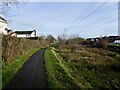
Balancing Lagoon
A bit of suburban wildlife habitat created to deal with excess runoff water as new housing was constructed in the 80s and now rarely filled . A rather old sign told of slow worms having been found here . Its good to see that a bit of tidying has been done this winter.
Image: © Andrew Darge
Taken: 11 Dec 2020
0.04 miles
3
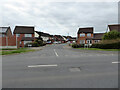
Alton Road across St Peter's Drive, Worcester
In the large St Peter The Great housing development. St Peter's Drive is the spine road that loops through the development from end to end and provides access to all the secondary branches and cul-de-sacs that constitute this development. It is analogous to Warndon Villages towards the other end of the Worcester bypass.
Image: © Chris Allen
Taken: 21 Mar 2021
0.04 miles
4
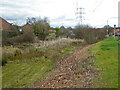
SUDS in St Peter The Great
Although described as wetlands by a fellow contributor, I believe this and at least two similar damp patches are actually part of a sustainable urban drainage scheme (SUDS) associated with a large area of housing development known as St Peter The Great (or just St Peter's).
Image: © Chris Allen
Taken: 21 Mar 2021
0.04 miles
5
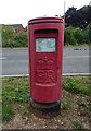
Elizabeth II postbox on St Peter's Drive, Worcester
Postbox No. WR5 413.
Image: © JThomas
Taken: 13 Aug 2021
0.04 miles
6
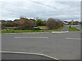
The junction of Norton Road and St Peter's Drive, Worcester
Norton Road to the left is a cul -de-sac leading to a path and cycleway. St Peter's Drive is the spine road through the St Peter The Great housing development.
Image: © Chris Allen
Taken: 21 Mar 2021
0.05 miles
7
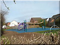
Equipped play area
This play area has just been completely renewed it serves the St Peters estate beside the old Norton road and power park.
Image: © Andrew Darge
Taken: 24 Mar 2009
0.06 miles
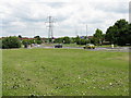
8

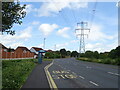
Pylons above St Peters Drive
These pylons pass through the St Peter's housing estate. The Malvern Hills can be seen on the horizon.
Image: © Philip Halling
Taken: 27 May 2010
0.06 miles
9
St Peter's Way
One end of the spine road for the St Peter The Great housing estates.
Image: © Peter Whatley
Taken: 24 Jun 2008
0.06 miles
10
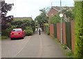
Saltwells pedway
The St Peters estate is well supplied with paths that shorten your way on foot or cycle . This one cuts through to Tesco.
Image: © Andrew Darge
Taken: 3 Jun 2009
0.06 miles