IMAGES TAKEN NEAR TO
Main Road, WORCESTER, WR5 3PA
Introduction
This page details the photographs taken nearby to Main Road, WR5 3PA by members of the Geograph project.
The Geograph project started in 2005 with the aim of publishing, organising and preserving representative images for every square kilometre of Great Britain, Ireland and the Isle of Man.

There are currently over 7.5m images from over14,400 individuals and you can help contribute to the project by visiting https://www.geograph.org.uk
Image Map
Images are licensed for reuse under creativecommons.org/licenses/by-sa/2.0
Notes
- Clicking on the map will re-center to the selected point.
- The higher the marker number, the further away the image location is from the centre of the postcode.
Image Listing (43 Images Found)
Images are licensed for reuse under creativecommons.org/licenses/by-sa/2.0
Image
Details
Distance
1
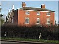
Old Baynhall Farmhouse
Near Kempsey, Worcestershire. Early to mid-19th century and Listed Grade II.
Image: © Chris Allen
Taken: 1 Feb 2022
0.00 miles
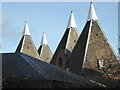
2
Former hop kilns near Kempsey
These are erroneously titled oast houses but in this part of the world they were usually referred to as hop kilns. Three of the four are visible from this angle that is against the afternoon winter sun. They are now converted to dwellings.
Image: © Chris Allen
Taken: 1 Feb 2022
0.02 miles
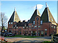
3
Converted hop kilns at Baynhall Farm near Kempsey
These are now houses. This angle shows all four and was also better illuminated than the accessible alternative.
Image: © Chris Allen
Taken: 1 Feb 2022
0.02 miles
4
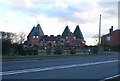
Baynhall Farm, near Kempsey
Former hop kilns, now converted into apartments.
Image: © Eirian Evans
Taken: 8 Jan 2011
0.02 miles
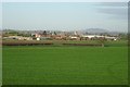
5
Baynhall Farm, near Kempsey
Viewed across a frosty field, the buildings of Baynhall Farm, including the hop kilns, have been converted into residential accommodation. The Malvern Hills can be seen in the background on the horizon.
Image: © Philip Halling
Taken: 5 Mar 2008
0.06 miles
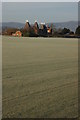
6
Baynhall Farm
The hopkilns of Baynhill Farm have been converted to residential accommodation. The tower of Stanbrook Abbey, now a hotel, can be seen at Callow End in the background. The Abberley Hills can be seen on the horizon. The field in the foreground is growing turf.
Image: © Philip Halling
Taken: 9 Jan 2019
0.07 miles
9
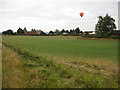
Hot air balloon over Baynhall Farm
A hot air balloon floats over Baynhall Farm on a grey August morning.
Image: © Philip Halling
Taken: 3 Aug 2010
0.10 miles
10
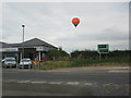
Hot air balloon over Baynhall Garage
Image: © Philip Halling
Taken: 3 Aug 2010
0.10 miles