IMAGES TAKEN NEAR TO
Peninsula Road, WORCESTER, WR5 2SE
Introduction
This page details the photographs taken nearby to Peninsula Road, WR5 2SE by members of the Geograph project.
The Geograph project started in 2005 with the aim of publishing, organising and preserving representative images for every square kilometre of Great Britain, Ireland and the Isle of Man.

There are currently over 7.5m images from over14,400 individuals and you can help contribute to the project by visiting https://www.geograph.org.uk
Image Map
Images are licensed for reuse under creativecommons.org/licenses/by-sa/2.0
Notes
- Clicking on the map will re-center to the selected point.
- The higher the marker number, the further away the image location is from the centre of the postcode.
Image Listing (59 Images Found)
Images are licensed for reuse under creativecommons.org/licenses/by-sa/2.0
Image
Details
Distance
1
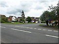
Gazala Drive seen from Crookbarrow Road, Norton
Gazala was a battle in the Western Desert Campaign of 1942. I wonder how many of the occupants of Norton know that many streets are named after military actions.
Image: © Chris Allen
Taken: 9 Aug 2021
0.07 miles
2
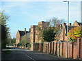
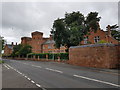
Crookbarrow Road Passing Old Norton Barracks Converted to Apartments
Image: © Roy Hughes
Taken: 28 Oct 2017
0.09 miles
3
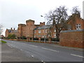
The former Norton Barracks
Now converted to housing with this being the only original block left.
Norton Barracks may ring bells with some as it was twice searched for the remains of missing estate agent Suzy Lamplugh. Her remains have still not been found although she is presumed dead.
Image: © Chris Allen
Taken: 14 Dec 2014
0.09 miles
5

Talavera Road
Modern housing estate close to the old Norton Barracks. A rapidly growing satellite village to the city of Worcester.
Image: © Bob Embleton
Taken: 1 Sep 2007
0.10 miles
7
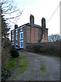
Newlands Farmhouse, Norton
Late 18th century red brick, three storey house. Listed Grade II. Photographed across the gate line.
Image: © Chris Allen
Taken: 9 Jan 2022
0.10 miles
8

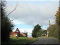
Brockhill Lane, Norton, Worcestershire
The path straight ahead leads to Crookbarrow Hill. The road to the left carries a path to St Peter the Great and on towards the city centre (Worcester).
Image: © Chris Allen
Taken: 9 Aug 2021
0.10 miles
9
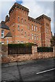
Norton Barracks
Norton Barracks was in use by the army until 1962; the building has now been converted into residential accommodation.
Image: © Philip Halling
Taken: 21 Feb 2015
0.11 miles
10

Norton Barracks (1)
Formerly home of the Worcestershire Regiment and now apartments. The style is Fortress Gothic Revival and they were built between 1874 and 1877.
Image: © Jeff Gogarty
Taken: 9 Jul 2020
0.11 miles