IMAGES TAKEN NEAR TO
Norwich Road, WORCESTER, WR5 1NX
Introduction
This page details the photographs taken nearby to Norwich Road, WR5 1NX by members of the Geograph project.
The Geograph project started in 2005 with the aim of publishing, organising and preserving representative images for every square kilometre of Great Britain, Ireland and the Isle of Man.

There are currently over 7.5m images from over14,400 individuals and you can help contribute to the project by visiting https://www.geograph.org.uk
Image Map
Images are licensed for reuse under creativecommons.org/licenses/by-sa/2.0
Notes
- Clicking on the map will re-center to the selected point.
- The higher the marker number, the further away the image location is from the centre of the postcode.
Image Listing (86 Images Found)
Images are licensed for reuse under creativecommons.org/licenses/by-sa/2.0
Image
Details
Distance
1
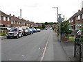
Ronkswood - Canterbury Road (west side)
Canterbury Road forms a loop around the Ronkswood estate. This is on the western side, taken from just below the junction with Lichfield Avenue and the access to the local primary school. Quick photography recommended.
Image: © Peter Whatley
Taken: 23 Jun 2008
0.03 miles
2
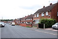
Canterbury Rd
This long residential street with social housing dating from the fifties and sixties is in Ronkswood on the east side of the city.
Image: © Nigel Mykura
Taken: 28 Sep 2019
0.04 miles
3
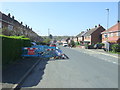
Roadworks on Canterbury Road, Ronkswood
Looking south west.
Image: © JThomas
Taken: 8 Apr 2017
0.05 miles
4
The Punch Bowl
The Punch Bowl in Ronkswood.
Image: © Philip Halling
Taken: 10 Jul 2020
0.07 miles
5
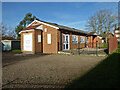
MGM Philadelphia Christian Assembly, Ronkswood, Worcester
Image: © Chris Allen
Taken: 1 Dec 2020
0.07 miles
6
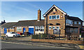
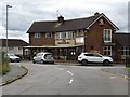
Punchbowl public house, Ronkswood, Worcester
This public house on a council house estate is listed in a book of traditional British pubs by virtue of its unspoilt post war interior. I must confess to not having been in. Lockdown gave me a chance to photograph it without any body else in the frame but this is not its best side.
Image: © Chris Allen
Taken: 1 Dec 2020
0.07 miles
7
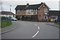
The Punch Bowl
The Punch Bowl public house on Lichfield Avenue in Ronkswood.
Image: © Philip Halling
Taken: 18 Jan 2014
0.07 miles
9
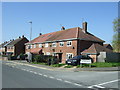
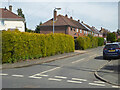
Westminster Road, Ronkswood Estate
A large council housing estate with roads named after places with cathedrals (I had thought they were all named after cities but one or two are not - like Guildford). This is seen from the junction with Canterbury Road.
Image: © Chris Allen
Taken: 15 Mar 2021
0.07 miles
10
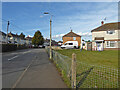
Norwich Road, Worcester
Seen from the junction with Canterbury Road on the Ronkswood estate. This is a large social housing estate.
Image: © Chris Allen
Taken: 24 Apr 2021
0.08 miles