IMAGES TAKEN NEAR TO
Newtown Road, WORCESTER, WR5 1HR
Introduction
This page details the photographs taken nearby to Newtown Road, WR5 1HR by members of the Geograph project.
The Geograph project started in 2005 with the aim of publishing, organising and preserving representative images for every square kilometre of Great Britain, Ireland and the Isle of Man.

There are currently over 7.5m images from over14,400 individuals and you can help contribute to the project by visiting https://www.geograph.org.uk
Image Map
Images are licensed for reuse under creativecommons.org/licenses/by-sa/2.0
Notes
- Clicking on the map will re-center to the selected point.
- The higher the marker number, the further away the image location is from the centre of the postcode.
Image Listing (52 Images Found)
Images are licensed for reuse under creativecommons.org/licenses/by-sa/2.0
Image
Details
Distance
1
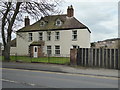
Ronkswood Hill Farm
An unlikely place for a farm but there are cows in the fields behind in the summer.
Image: © Chris Allen
Taken: 5 Mar 2016
0.03 miles
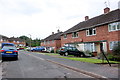
2
Hillside Close, Worcester
Off Newtown Road as it climbs away from the city centre. Perry Wood is seen in the background.
Image: © Chris Allen
Taken: 16 Sep 2019
0.03 miles
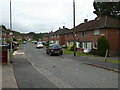
3
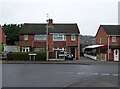
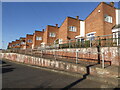
Social Housing Hillside Close
Hillside close is just off the Newtown Rd. It is probable that some of this housing is now in private hands.
Image: © Nigel Mykura
Taken: 28 Sep 2019
0.04 miles
4
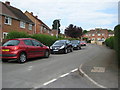
Solent Road
Solent Road in Ronkswood, Worcester.
Image: © Philip Halling
Taken: 1 Jul 2009
0.07 miles
5
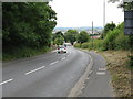
Down the hill to Worcester
Newtown Road drops away from Ronkswood in the direction of Shrub Hill station. The photo was taken from slightly closer in toward Worcester than the former Clinical Research Centre, now closed (June 2008). The hills beyond the River Severn are visible in the distance.
Image: © Peter Whatley
Taken: 23 Jun 2008
0.08 miles
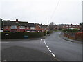
6
The junction of Ronkswood Hill and Don Road, Worcester
Ronkswood Hill starts behind the photographer and comes to a T-junction here. Ronkswood takes 90 degree turn to the left and Don Road is to the right.
Image: © Chris Allen
Taken: 27 Dec 2019
0.09 miles
7
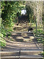
Steps in Perry Wood, Worcester
I had never seen these before so followed them to the top only to find a locked gate to the grounds of Perry Wood Primary School
Image: © Chris Allen
Taken: 9 Feb 2023
0.09 miles
8
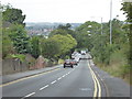
Looking down Newtown Road, Worcester
Looking down towards the town centre. This is quite steep, especially on foot.
Image: © Chris Allen
Taken: 29 Aug 2019
0.10 miles
10
The junction of Wolsey Close and Don Road, Worcester
These properties have the look of council/social housing. There is an awful lot in Worcester. Wolsey close is to the left and Don road straight ahead.
Image: © Chris Allen
Taken: 27 Dec 2019
0.11 miles