IMAGES TAKEN NEAR TO
Heron End, WORCESTER, WR5 1AR
Introduction
This page details the photographs taken nearby to Heron End, WR5 1AR by members of the Geograph project.
The Geograph project started in 2005 with the aim of publishing, organising and preserving representative images for every square kilometre of Great Britain, Ireland and the Isle of Man.

There are currently over 7.5m images from over14,400 individuals and you can help contribute to the project by visiting https://www.geograph.org.uk
Image Map
Images are licensed for reuse under creativecommons.org/licenses/by-sa/2.0
Notes
- Clicking on the map will re-center to the selected point.
- The higher the marker number, the further away the image location is from the centre of the postcode.
Image Listing (258 Images Found)
Images are licensed for reuse under creativecommons.org/licenses/by-sa/2.0
Image
Details
Distance
1
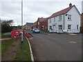
Heron End, Whittington Walk
This is the far end of the phase 2 development of Whittington Walk and the houses are all complete. The road still needs its final surfacing. A newly laid path starts on the left but is currently blocked by phase 3 works.
Image: © Chris Allen
Taken: 5 Feb 2022
0.01 miles
2
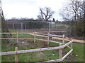
Whittington Walk, newly laid path
On the new housing development and leading from phase 2 towards the edge of phase 3. Not currently passable due to the Heras fencing.
Image: © Chris Allen
Taken: 5 Feb 2022
0.02 miles
3
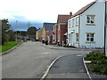
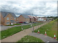
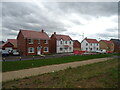
Whittington Walk housing development, Worcester - phase 2
This shows the junction of Heron End with Willow Bank at the far end of the almost finished phase 2. Phase 3 is now well under way.
Image: © Chris Allen
Taken: 9 Nov 2021
0.02 miles
4
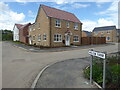
Whittington Walk housing development, Worcester - Willow Bank
These are the most recent houses to be completed and not all are occupied yet. Work on phase 2 is continuing out of sight to the left. Phase 3 is still at the groundworks stage.
Image: © Chris Allen
Taken: 4 Jul 2021
0.02 miles
5
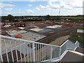
Whittington Walk housing development, Worcester
Seen from the new footbridge over the A4440. This bridge had not been open for long and this was my first wander onto it. Out of sight to the left there is a mixture of completed and part finished houses but in this view it is footings only. There is a supply of wooden roof trusses visible in the distance. A public footpath continues between Heras fencing to the right.
Image: © Chris Allen
Taken: 22 Aug 2020
0.03 miles
6
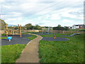
Children's playground, Whittington Walk
Image: © Chris Allen
Taken: 28 Oct 2022
0.03 miles
7
Whittington Walk - new play area
A new children's play area that is not yet open.
Image: © Chris Allen
Taken: 9 Apr 2022
0.03 miles
8
Whittington Walk housing development, Worcester
Seen from the footbridge over the A4440. The nearest houses are finished and occupied but those in the distance are still in an active building site.
Image: © Chris Allen
Taken: 10 Jun 2021
0.04 miles
10
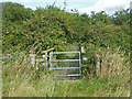
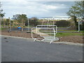
Public footpath near Whittington
This path is looking a little underutilised and overgrown, possibly in part because of building works alongside part of it. At this point it crosses a little stream by means of a gated footbridge.
Image: © Chris Allen
Taken: 21 Aug 2019
0.04 miles