IMAGES TAKEN NEAR TO
Chedworth Close, WORCESTER, WR4 9YG
Introduction
This page details the photographs taken nearby to Chedworth Close, WR4 9YG by members of the Geograph project.
The Geograph project started in 2005 with the aim of publishing, organising and preserving representative images for every square kilometre of Great Britain, Ireland and the Isle of Man.

There are currently over 7.5m images from over14,400 individuals and you can help contribute to the project by visiting https://www.geograph.org.uk
Image Map
Images are licensed for reuse under creativecommons.org/licenses/by-sa/2.0
Notes
- Clicking on the map will re-center to the selected point.
- The higher the marker number, the further away the image location is from the centre of the postcode.
Image Listing (57 Images Found)
Images are licensed for reuse under creativecommons.org/licenses/by-sa/2.0
Image
Details
Distance
1
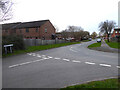
Junction of Chedworth Close and Chedworth Drive, Warndon, Worcester
In a large housing estate.
Image: © Chris Allen
Taken: 23 Feb 2021
0.05 miles
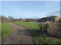
2
Entrance to Warndon Play Park
On the edge of a large council housing estate in Worcester.
Image: © Chris Allen
Taken: 23 Feb 2021
0.06 miles
3

Elephant outside Worcester Bosch
One of the various sponsored elephants that were arranged around the city in a previous year seems to have found its forever home with the makers of gas central heating boilers.
Image: © Chris Allen
Taken: 19 Feb 2023
0.07 miles
4
Play area behind Rodborough Close, Warndon, Worcester
Cotswold Way is out of sight to the left.
Image: © Chris Allen
Taken: 15 Feb 2021
0.07 miles
6
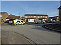
Police activity on Rodborough Drive, Worcester
Three police vehicles including a forensics van outside a house in Worcester. The photographer is on Chalford Drove and there is new housing development to the right. The local newspaper revealed that this was a raid on a cannabis factory in a domestic dwelling. Some unusual excitement on my strolls around Worcester.
Image: © Chris Allen
Taken: 15 Feb 2021
0.09 miles
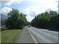
7
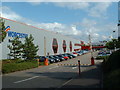
Worcester Bosch
Factory Units north of the B4639
Image: © Chris Shaw
Taken: Unknown
0.09 miles
8
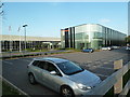
Mazak factory, Worcester
Modern factory specialising in machine tool manufacture. There is a lot more engineering undertaken in Worcester than one might first think.
Yamazaki Mazak is the world's largest builder of metal machining tools with a worldwide presence. The UK plant in Worcester is the European manufacturing plant and UK Technology Centre.
Image: © Chris Allen
Taken: 29 Sep 2013
0.09 miles
9
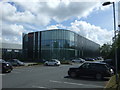
Yamazaki Mazak UK Ltd.
CNC Machine Tools & Manufacturing Systems.
Image: © JThomas
Taken: 22 Jul 2017
0.09 miles
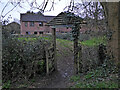
10
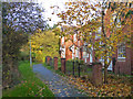
Behind Homestead Avenue, Wall Meadow
Homestead Avenue is the longest road in Wall Meadow and peters out in a path running behind this short row of houses and joining a combined footpath and cyclepath paralleling the B4639 Cotswold Way.
Image: © Chris Allen
Taken: 4 Nov 2019
0.10 miles