IMAGES TAKEN NEAR TO
Grasmere Drive, WORCESTER, WR4 9HL
Introduction
This page details the photographs taken nearby to Grasmere Drive, WR4 9HL by members of the Geograph project.
The Geograph project started in 2005 with the aim of publishing, organising and preserving representative images for every square kilometre of Great Britain, Ireland and the Isle of Man.

There are currently over 7.5m images from over14,400 individuals and you can help contribute to the project by visiting https://www.geograph.org.uk
Image Map
Images are licensed for reuse under creativecommons.org/licenses/by-sa/2.0
Notes
- Clicking on the map will re-center to the selected point.
- The higher the marker number, the further away the image location is from the centre of the postcode.
Image Listing (79 Images Found)
Images are licensed for reuse under creativecommons.org/licenses/by-sa/2.0
Image
Details
Distance
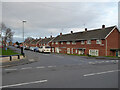
1
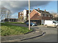
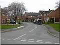
Ullswater Close, Warndon, Worcester
Part of a large social housing estate with streets named after places in the Lake District. Seen from its junction with Grasmere Drive.
Image: © Chris Allen
Taken: 19 Jan 2023
0.03 miles
2
Path leading from Ennerdale Close to Borrowdale Drive, Worcester
In the midst of the large social housing estate that is Warndon. I don't know if I've been down this one or not before because the place is an absolute warren.
Image: © Chris Allen
Taken: 19 Jan 2023
0.06 miles
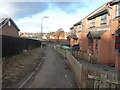
3
Ennerdale Close, Warndon, Worcester
This close is T-shaped and the cross-piece of the T is flanked by several low-rise developments as seen here.
Image: © Chris Allen
Taken: 2 May 2021
0.07 miles
4
Ennerdale Close, Warndon, Worcester
Seen from the footpath linking it to Ullswater close. A large social housing estate with streets named after places in the Lake District. This is an absolute warren and I often find myself not knowing where I've been and photographed before. I really must stop going near school closing time too.
Image: © Chris Allen
Taken: 19 Jan 2023
0.08 miles
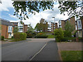
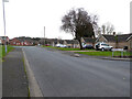
5
Borrowdale Drive from Langdale Drive, Warndon
A large housing estate with streets named after places in the Lake District.
Image: © Chris Allen
Taken: 6 Mar 2021
0.08 miles
6
Rothay Close, Warndon, Worcester
The streets in this large council housing estate are named after places in the Lake District. This is seen from its junction with Grasmere Drive.
Image: © Chris Allen
Taken: 19 Jan 2023
0.09 miles
7
Ennerdale Close, Warndon, Worcester
A large council housing estate.
Image: © Chris Allen
Taken: 6 Mar 2021
0.09 miles
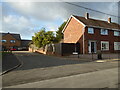
8
Brantwood from Warndon Green, Worcester
Image: © Chris Allen
Taken: 23 Feb 2021
0.10 miles
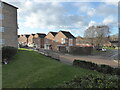
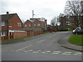
9
Grasmere Drive, Warndon, Worcester
A large housing estate with the streets named after places in the Lake District. Warndon is not to be confused with the nearby Warndon Villages where life expectancy is claimed to be 12 years longer.
Image: © Chris Allen
Taken: 21 Nov 2020
0.10 miles
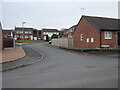
10
Warndon Green, Worcester
The sign on the right for Glenridding Close refers to a street that is out of sight to the right and perpendicular to the view direction. On this occasion the sign does not refer to the road I am photographing.
Image: © Chris Allen
Taken: 23 Feb 2021
0.11 miles