IMAGES TAKEN NEAR TO
Burdett Place, WORCESTER, WR4 0QT
Introduction
This page details the photographs taken nearby to Burdett Place, WR4 0QT by members of the Geograph project.
The Geograph project started in 2005 with the aim of publishing, organising and preserving representative images for every square kilometre of Great Britain, Ireland and the Isle of Man.

There are currently over 7.5m images from over14,400 individuals and you can help contribute to the project by visiting https://www.geograph.org.uk
Image Map
Images are licensed for reuse under creativecommons.org/licenses/by-sa/2.0
Notes
- Clicking on the map will re-center to the selected point.
- The higher the marker number, the further away the image location is from the centre of the postcode.
Image Listing (132 Images Found)
Images are licensed for reuse under creativecommons.org/licenses/by-sa/2.0
Image
Details
Distance
1
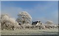
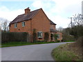
Cottage on Trotshill Lane
Seen from the field south of the lane, one of the bits of green preserved in the Warndon villages development north west of Worcester.
Image: © Andrew Darge
Taken: 7 Dec 2010
0.03 miles
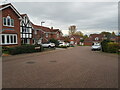
3
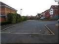
Looking along Cobden Avenue, Harley Whitefort
The view direction is along curving Cobden Avenue and I am stood at the junction with Hunt Avenue. The latter runs out of view to the right. This is one small corner of the huge complex that is Warndon Villages
Image: © Chris Allen
Taken: 25 Jan 2019
0.04 miles
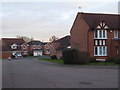
4
Hunt Avenue, Harley-Whitefort
Seen from Cobden Avenue. The Harleys are one subdivision of Warndon Villages and Whitefort is just one of the Harleys. I had already traversed Harley-Warren and Harley-Bakewell to reach this point.
Image: © Chris Allen
Taken: 24 Nov 2019
0.05 miles
5
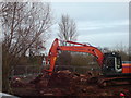
Trotshill Manor revealed by redevelopment next door
Two of these large machines are working to install drains on this site between Warndon villages and the A4440 ring road.
Image: © Andrew Darge
Taken: 8 Dec 2009
0.05 miles
7
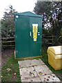
Electricity infrastructure, Trotshill, Worcester
A Western Power cabinet with the usual warnings regarding danger of death, forensic marking and sulfur hexafluoride (I can't get used to the new spelling of sulfur).
Image: © Chris Allen
Taken: 12 Nov 2020
0.05 miles
8
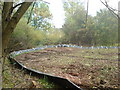
Collecting Crested Newts beside Trotshill Manor
The whole perimeter of this small site for new houses was fitted with this plastic fence. Apparently a condition of the redevelopment was that these rare newts were collected and relocated. To this end a bucket was sunk to ground level every few yards around the whole site and inspected every day for newts.
Image: © Andrew Darge
Taken: 15 Oct 2009
0.06 miles
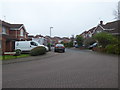
9
The end of Cobden Avenue, Harley-Whitefort
Cobden avenue is a sinuous cul-de-sac in Harley-Whitefort. It is seen from the public footpath that separates the Harleys from the Lyppards and runs to Trotshill. Warndon Villages is a complete warren (including Harley-Warren) and provides hundreds of different views of roads, paths and junctions.
Image: © Chris Allen
Taken: 12 Nov 2020
0.06 miles
10
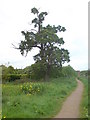
Old oak and muddy pond
Warndon is well supplied with paths and walkways in the green space between the housing and the link road and motorway . Here behind the irises is a muddy pool (beloved of our chocolate labrador) and an ancient oak.
Image: © Andrew Darge
Taken: 22 May 2009
0.06 miles