IMAGES TAKEN NEAR TO
Muncaster Place, WORCESTER, WR4 0EA
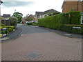
Introduction
This page details the photographs taken nearby to Muncaster Place, WR4 0EA by members of the Geograph project.
The Geograph project started in 2005 with the aim of publishing, organising and preserving representative images for every square kilometre of Great Britain, Ireland and the Isle of Man.

There are currently over 7.5m images from over14,400 individuals and you can help contribute to the project by visiting https://www.geograph.org.uk
Image Map
Images are licensed for reuse under creativecommons.org/licenses/by-sa/2.0
Notes
- Clicking on the map will re-center to the selected point.
- The higher the marker number, the further away the image location is from the centre of the postcode.
Image Listing (74 Images Found)
Images are licensed for reuse under creativecommons.org/licenses/by-sa/2.0
Image
Details
Distance
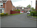
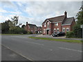
1
Walkworth Avenue, Berkeley-Pendesham, Worcester
Seen from Corfe Avenue. Virtually all the street names in the Berkeleys seem to be after places with castles. However Walkworth is not a castle but Warkworth is. Perhaps somebody got the spelling wrong.
Image: © Chris Allen
Taken: 22 May 2021
0.03 miles
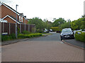
2
Sudeley Avenue, Berkeley-Pendesham
From Corfe Avenue. All the streets in the Berkeleys seem to be named after castles. Block paving at junctions is a feature of Warndon Villages.
Image: © Chris Allen
Taken: 9 Jan 2020
0.04 miles
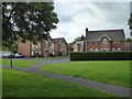
3
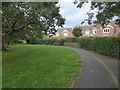
Path through Berkeley Beverborne
This is one of the many green paths that pass through and link the various parts of the large area of housing known as Warndon Villages. On the right is Bamburgh Crescent (Streetview confirms this from the rooflines).
Image: © Chris Allen
Taken: 6 Oct 2019
0.06 miles
4

Lewes Gardens from Corfe Avenue
This part of Warndon Villages is Berkeley-Pendesham and the street names seem to have a possible castle theme. I am stood in Corfe Avenue and Lewes Gardens extends to the left.
Image: © Chris Allen
Taken: 6 Oct 2019
0.06 miles
5
Castell Place, Berkeley-Pendesham, Worcester
In an area where the street names nearly all appear to have connections with places with castles this one is named after the Welsh for castle. Seen from Corfe Avenue (see what I mean!).
Image: © Chris Allen
Taken: 22 May 2021
0.06 miles
6
Farnham Green, Berkeley-Pendesham, Worcester
Seen from Corfe Avenue. Yet another street in this complex that appears to be named after a place with a castle.
One of the large council estates in Worcester seems to have a similar theme going for places with cathedrals and another council estate seems to major on places in the Lake District.
Image: © Chris Allen
Taken: 22 May 2021
0.08 miles
7
Walmer Crescent, Berkeley-Pendesham
The street names in the Berkeleys all appear to be after places with castles. Some are relatively obscure but I keep looking them up and the castles keep coming. None of the other complexes in Warndon Villages seem to have such a single-minded system of nomenclature.
Image: © Chris Allen
Taken: 22 May 2021
0.09 miles
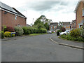
8
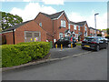
Bamburgh Crescent, Berkeley-Pendesham, Worcester
Part of Warndon Villages. There is an electricity substation in the building on the left.
Image: © Chris Allen
Taken: 19 May 2021
0.09 miles
9
Walmer Crescent - Berkeley Pendesham
This is in the Berkeleys area of Warndon Villages and a planning application I found on line places it in Berkeley Pendesham. It is difficult enough knowing which rough area you are in within Warndon Villages, so I normally rely on including a street name as it is stated on the signs. This view is from one of the many paths that traverse green areas between the individual 'villages'.
Image: © Chris Allen
Taken: 6 Oct 2019
0.10 miles
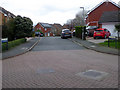
10
Corfe Avenue from Hastings Drive
This is in the Berkeley-Pendesham area of Warndon Villages. Warndon Villages are under-represented on Geograph but they do tend to be labyrinthine and all resemble one another.
Image: © Chris Allen
Taken: 6 Oct 2019
0.11 miles