IMAGES TAKEN NEAR TO
Kennels Lane, WORCESTER, WR3 7RZ
Introduction
This page details the photographs taken nearby to Kennels Lane, WR3 7RZ by members of the Geograph project.
The Geograph project started in 2005 with the aim of publishing, organising and preserving representative images for every square kilometre of Great Britain, Ireland and the Isle of Man.

There are currently over 7.5m images from over14,400 individuals and you can help contribute to the project by visiting https://www.geograph.org.uk
Image Map
Images are licensed for reuse under creativecommons.org/licenses/by-sa/2.0
Notes
- Clicking on the map will re-center to the selected point.
- The higher the marker number, the further away the image location is from the centre of the postcode.
Image Listing (6 Images Found)
Images are licensed for reuse under creativecommons.org/licenses/by-sa/2.0
Image
Details
Distance
1
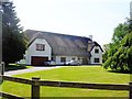
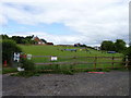
Worcester Hunt Kennels
On Kennels Lane, Fernhill Heath
Two horses are sheltering from sun under the tree on the right.
Image: © Jeff Gogarty
Taken: 21 Jun 2015
0.06 miles
2
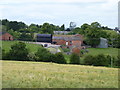
Worcester Hunt Kennels associated buildings
Taken from Station Road, Fernhill Heath
Image: © Jeff Gogarty
Taken: 21 Jun 2015
0.07 miles
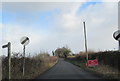
4
Dog agility equipment
Dog training area on Kennels Lane, Fernhill Heath
Image: © Jeff Gogarty
Taken: 21 Jun 2015
0.13 miles
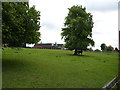
5
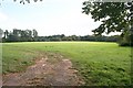
Pasture near Acorns Farm
Acorns farm (behind the camera) is just off Station Road which runs south into Fernhill Heath.
Image: © Bob Embleton
Taken: 16 Sep 2007
0.20 miles