IMAGES TAKEN NEAR TO
Sailors Bank, WORCESTER, WR2 6QT
Introduction
This page details the photographs taken nearby to Sailors Bank, WR2 6QT by members of the Geograph project.
The Geograph project started in 2005 with the aim of publishing, organising and preserving representative images for every square kilometre of Great Britain, Ireland and the Isle of Man.

There are currently over 7.5m images from over14,400 individuals and you can help contribute to the project by visiting https://www.geograph.org.uk
Image Map
Images are licensed for reuse under creativecommons.org/licenses/by-sa/2.0
Notes
- Clicking on the map will re-center to the selected point.
- The higher the marker number, the further away the image location is from the centre of the postcode.
Image Listing (32 Images Found)
Images are licensed for reuse under creativecommons.org/licenses/by-sa/2.0
Image
Details
Distance
1
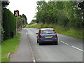
Speeding up Sailor's Bank
This car slowed down remarkably quickly when the driver realised I had a camera! The speed limit on the B4204 has been 30 for around one hundred yards, due to the number of houses with accesses having restricted visibility onto the road.
Image: © Peter Whatley
Taken: 31 Jul 2008
0.01 miles
2
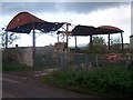
Dilapidated Barn, Peachley Court Farm
A corrugated iron roofed barn in a wonderful state of decay.
An email received suggested : "Destroyed by fire, children suspect arsonists"
Image: © Bob Embleton
Taken: 12 Nov 2005
0.05 miles
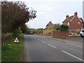
5
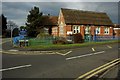
Broadheath Primary School
Broadheath C of E Primary School is situated opposite the parish church.
Image: © Philip Halling
Taken: 24 Jan 2010
0.10 miles
6
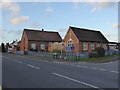
Broadheath Church of England Primary School
Image: © Chris Allen
Taken: 10 Jan 2015
0.10 miles
7
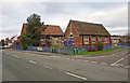
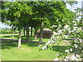
Broadheath Church of England Primary School (1), Sailor's Bank, Lower Broadheath
Located on the corner of Sailor's Bank and Church Lane. The school was built in the early 1870's, but in the early 1900's the original church, dating from 1836, was incorporated into the school to give extra space. This was possible because its replacement, the new Christ Church, was built in 1903/04.
Image
Image
Image: © P L Chadwick
Taken: 27 Dec 2011
0.11 miles
8
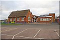
Broadheath Church of England Primary School (2), Sailor's Bank, Lower Broadheath
This view is of the frontage to Church Lane. The school was built in the early 1870's, incorporated the former church of 1836 in the early 1900's, and since then there have been modern additions.
Image
Image
Image: © P L Chadwick
Taken: 27 Dec 2011
0.12 miles
9

Broadheath Church of England Primary School (3) - sign, Sailor's Bank, Lower Broadheath
Image: © P L Chadwick
Taken: 27 Dec 2011
0.12 miles
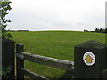
10
Peachley Leisure
The entrance to Peachley Leisure Touring Caravan Park sets the mood for the secluded and beautiful surroundings.
Image: © Philip Arnold
Taken: 8 Jun 2008
0.12 miles