IMAGES TAKEN NEAR TO
Parkfield Lane, WORCESTER, WR2 6PJ
Introduction
This page details the photographs taken nearby to Parkfield Lane, WR2 6PJ by members of the Geograph project.
The Geograph project started in 2005 with the aim of publishing, organising and preserving representative images for every square kilometre of Great Britain, Ireland and the Isle of Man.

There are currently over 7.5m images from over14,400 individuals and you can help contribute to the project by visiting https://www.geograph.org.uk
Image Map
Images are licensed for reuse under creativecommons.org/licenses/by-sa/2.0
Notes
- Clicking on the map will re-center to the selected point.
- The higher the marker number, the further away the image location is from the centre of the postcode.
Image Listing (27 Images Found)
Images are licensed for reuse under creativecommons.org/licenses/by-sa/2.0
Image
Details
Distance
1
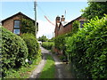
Hallow - Parkfield Lane
This is the bottom end of the lane which leaves the A443 at Parkfield Nurseries and rapidly becomes a narrow track, flanked by a varied collection of houses. While I was taking pictures the refuse truck arrived and reversed down the whole lane: quite an entertaining few minutes.
Image: © Peter Whatley
Taken: 19 Jun 2008
0.02 miles
2
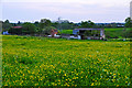
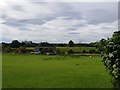
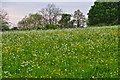
Little Eastbury : Grassy Field
Looking across a grassy field from Parkfield Lane.
Image: © Lewis Clarke
Taken: 4 May 2014
0.03 miles
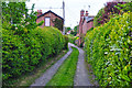
3
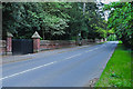
Little Eastbury : Parkfield Lane
A small lane leading to these houses from the main road.
Image: © Lewis Clarke
Taken: 4 May 2014
0.04 miles
4
Little Eastbury : Parkfield Lane
Looking along a small track at Parkfield Lane.
Image: © Lewis Clarke
Taken: 4 May 2014
0.04 miles
5
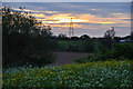
Horses in a field near Little Eastbury, Worcestershire
Taken from Parkfield Lane.
Image: © Jeff Gogarty
Taken: 13 Jul 2020
0.05 miles
6
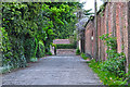
Little Eastbury : Parkfield Lane
Looking along Parkfield Lane as it heads towards Hallow Road.
Image: © Lewis Clarke
Taken: 4 May 2014
0.06 miles
7
Little Eastbury : Grassy Field
A grassy field close to Little Eastbury.
Image: © Lewis Clarke
Taken: 4 May 2014
0.08 miles
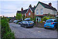
8
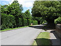
Nondescript suburbia
A singularly undistinguished section of the A443 on the southern edge of Hallow. The street sign for Parkfield Lane is just visible to the left of the car in the distance.
Image: © Peter Whatley
Taken: 19 Jun 2008
0.09 miles
9
Little Eastbury : Hallow Road A443
Looking along a road which heads from here towards Worcester.
Image: © Lewis Clarke
Taken: 4 May 2014
0.10 miles
10
Malvern Hills District : Grassy Field
A grassy field in the Malvern Hills District.
Image: © Lewis Clarke
Taken: 4 May 2014
0.11 miles