IMAGES TAKEN NEAR TO
Fitcher Close, WORCESTER, WR2 6DP
Introduction
This page details the photographs taken nearby to Fitcher Close, WR2 6DP by members of the Geograph project.
The Geograph project started in 2005 with the aim of publishing, organising and preserving representative images for every square kilometre of Great Britain, Ireland and the Isle of Man.

There are currently over 7.5m images from over14,400 individuals and you can help contribute to the project by visiting https://www.geograph.org.uk
Image Map
Images are licensed for reuse under creativecommons.org/licenses/by-sa/2.0
Notes
- Clicking on the map will re-center to the selected point.
- The higher the marker number, the further away the image location is from the centre of the postcode.
Image Listing (32 Images Found)
Images are licensed for reuse under creativecommons.org/licenses/by-sa/2.0
Image
Details
Distance
1
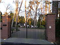
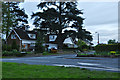
Worcester Gate, Hallow Road, Worcester
A gated detached home in this affluent suburb.
Image: © Jeremy Bolwell
Taken: 29 Nov 2012
0.09 miles
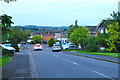
2
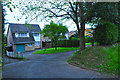
Worcester : Small Lane
A small lane off of Hallow Road.
Image: © Lewis Clarke
Taken: 4 May 2014
0.10 miles
3
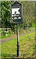
Coming Into Worcester
These very attractive signs are found on all the main roads coming into Worcester.
Image: © Mary and Angus Hogg
Taken: 27 Sep 2008
0.10 miles
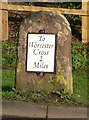
4
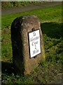
2 Miles To Worcester Cross
Milestone on Hallow Road, at the edge of Worcester city.
Image: © Mary and Angus Hogg
Taken: 27 Sep 2008
0.10 miles
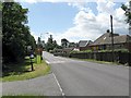
5
Worcester : Beaconhill Drive
Looking down Beaconhill Drive from Hallow Lane.
Image: © Lewis Clarke
Taken: 4 May 2014
0.10 miles
6
Old Milestone by the A443, Hallow Road, Worcester parish
Metal plate attached to stone post by the A443, in parish of WORCESTER (WORCESTER District), City boundary, Hallow Road, South corner of Little Eastbury, on the verge, close to road, on East side of road. Worcester Cross iron plate, erected by the Worcester turnpike trust in the 19th century.
Inscription reads:-
To
Worcester
Cross
2
Miles
Carved bench mark and rivet on top.
Milestone Society National ID: WO_WOGW02.
Image: © J Higgins
Taken: 20 Dec 2014
0.11 miles
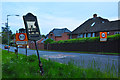
7
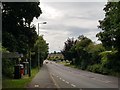
Welcome to Worcester
Worcester city's boundary is marked by signs, white-lined roads and a 30mph speed limit on the A443.
Image: © Peter Whatley
Taken: 19 Jun 2008
0.11 miles
8
Worcester : Hallow Road A443
Hallow Road heading into the city of Worcester as the signs suggest.
Image: © Lewis Clarke
Taken: 4 May 2014
0.11 miles
9
The A443 entering the edge of St Johns, Worcester
Image: © Jeff Gogarty
Taken: 13 Jul 2020
0.12 miles
10
Worcester : Bramley Lane
Looking across Hallow Road towards the junction with Bramley Lane.
Image: © Lewis Clarke
Taken: 4 May 2014
0.12 miles