IMAGES TAKEN NEAR TO
Columbia Drive, WORCESTER, WR2 4XR
Introduction
This page details the photographs taken nearby to Columbia Drive, WR2 4XR by members of the Geograph project.
The Geograph project started in 2005 with the aim of publishing, organising and preserving representative images for every square kilometre of Great Britain, Ireland and the Isle of Man.

There are currently over 7.5m images from over14,400 individuals and you can help contribute to the project by visiting https://www.geograph.org.uk
Image Map
Images are licensed for reuse under creativecommons.org/licenses/by-sa/2.0
Notes
- Clicking on the map will re-center to the selected point.
- The higher the marker number, the further away the image location is from the centre of the postcode.
Image Listing (42 Images Found)
Images are licensed for reuse under creativecommons.org/licenses/by-sa/2.0
Image
Details
Distance
1
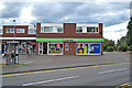
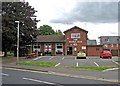
Shops on Canada Way, Lower Wick, Worcester
Seen from beside the Maple Leaf public house.
Image: © Chris Allen
Taken: 27 Mar 2021
0.15 miles
2
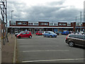
Co-operative Food store, 63-65 Canada Drive, Lower Wick, Worcester
Serving this large housing estate on the southwestern outskirts of Worcester, is this Co-operative food store. It is at the end of a small parade of shops, with a car park in front.
Image: © P L Chadwick
Taken: 1 Aug 2010
0.16 miles
3
The Maple Leaf - Your Local Community Pub
On Canada Way, Lower Wick.
Image: © Chris Allen
Taken: 27 Mar 2021
0.18 miles
4
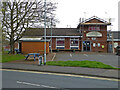
The Maple Leaf, 49 Canada Drive, Lower Wick, Worcester
Lower Wick is in the south west extremity of the city of Worcester, next door to the St. John's area. The Maple Leaf is the local estate pub for this large housing estate, where all the roads have Canadian themed names. The pub follows this practice, by being named after the national flag of Canada. The pub is on the corner of Canada Drive and Labrador Road. Canada Drive is the main estate road. The pub has a carvery, as well as Sky Sports.
Perhaps understandably, the pub doesn't use the Canadian flag as its sign; in fact it doesn't seem to have a traditional type of sign at all. When photographed, it did have a St. George's flag in one window. No doubt a leftover from the 2010 Work Cup football competition.
Image: © P L Chadwick
Taken: 1 Aug 2010
0.18 miles
5

Church of Jesus Christ and Latter Day Saints
An estate church in Lower Wick on the south-western outskirts of Worcester.
Image: © Jonathan Billinger
Taken: 18 May 2010
0.18 miles
6
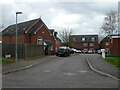
Mackenzie Close from Labrador road, Lower Wick, Worcester
Image: © Chris Allen
Taken: 27 Mar 2021
0.19 miles
7
The Church of Jesus Christ of Latter Day Saints, Lower Wick
On Canada Way.
Image: © Chris Allen
Taken: 27 Mar 2021
0.19 miles
8
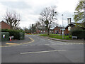
Labrador Road from Canada Way, Lower Wick, Worcester
The Maple Leaf public house is on the right. The local streets all have names linked to Canada.
Image: © Chris Allen
Taken: 27 Mar 2021
0.20 miles
9
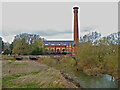
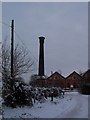
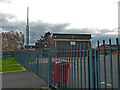
Worcester's first power station and the River Teme
Built 1894 with both hydropower from the Teme and steam power with reciprocating engines (hence the stunning chimney). Now apartments.
Image: © Chris Allen
Taken: 27 Mar 2021
0.21 miles