IMAGES TAKEN NEAR TO
Hospital Lane, WORCESTER, WR2 4SQ
Introduction
This page details the photographs taken nearby to Hospital Lane, WR2 4SQ by members of the Geograph project.
The Geograph project started in 2005 with the aim of publishing, organising and preserving representative images for every square kilometre of Great Britain, Ireland and the Isle of Man.

There are currently over 7.5m images from over14,400 individuals and you can help contribute to the project by visiting https://www.geograph.org.uk
Image Map
Images are licensed for reuse under creativecommons.org/licenses/by-sa/2.0
Notes
- Clicking on the map will re-center to the selected point.
- The higher the marker number, the further away the image location is from the centre of the postcode.
Image Listing (141 Images Found)
Images are licensed for reuse under creativecommons.org/licenses/by-sa/2.0
Image
Details
Distance
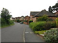
2
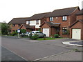
Collett's Green - Byron Close
Typical modern estate housing.
Image: © Peter Whatley
Taken: 12 Jun 2008
0.05 miles
3
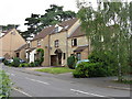
Collett's Green - King Charles Avenue
Modern terrace of housing crafted to have an old village appearnce. Somewhat given away by the presence of modern houses on either side and a profusion of satellite dishes.
Image: © Peter Whatley
Taken: 12 Jun 2008
0.07 miles