
IMAGES TAKEN NEAR TO
Old Road, WORCESTER, WR2 4BU
Introduction
This page details the photographs taken nearby to Old Road, WR2 4BU by members of the Geograph project.
The Geograph project started in 2005 with the aim of publishing, organising and preserving representative images for every square kilometre of Great Britain, Ireland and the Isle of Man.

There are currently over 7.5m images from over14,400 individuals and you can help contribute to the project by visiting https://www.geograph.org.uk
Image Map
Images are licensed for reuse under creativecommons.org/licenses/by-sa/2.0
Notes
- Clicking on the map will re-center to the selected point.
- The higher the marker number, the further away the image location is from the centre of the postcode.
Image Listing (121 Images Found)
Images are licensed for reuse under creativecommons.org/licenses/by-sa/2.0
Image
Details
Distance

2
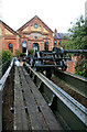
Powick Mills
This is a site long associated with water power but the building in the background is Worcester's first electric power station and the gable wall is dated 1894. It was a combined hydroelectric and reciprocating steam engine plant and was superseded in the 1920s. It is now housing. The hand worked travelling crane in the foreground formerly spanned one of the plant rooms.
Image: © Chris Allen
Taken: 30 Sep 2012
0.06 miles

5
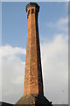
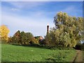
Chimney, Powick power station
This chimney was built to service the world's first combined steam/hydro-electric power station built in 1894.
Image: © Philip Halling
Taken: 1 Mar 2012
0.08 miles
6

Nineteenth-century benchmark on milestone
This benchmark was established in 1844 during the First primary levelling of England & Wales, and was levelled with a height of 54.972 feet [16.755 metres] above mean sea level (Liverpool datum). It was included on the Manchester to Gloucester levelling line. The surveyor's description was No. 388. Mark on the 2d milestone from Worcester, and 8th from Upton-on-Severn ; 3.73 ft. above centre of road (Public Abstract p.34). The mark no longer appears on the OS database, because the milestone is now inside the hedge, rendering the benchmark unusable.
Image: © Shantavira
Taken: 20 Nov 2015
0.08 miles
7

Old Milestone by the A449, Malvern Road, north of Powick Bridge
Metal plate attached to stone post by the A449, in parish of WORCESTER (WORCESTER District), 200 yds North of Powick Bridge, in hedgerow, on West side of road. Erected by the Worcester turnpike trust in the 19th century.
Inscription reads:-
TO
WORCESTER
CROSS
2
MILES
Milestone Society National ID: WO_WOLB02.
Image: © R Worth
Taken: 24 Nov 2002
0.08 miles

9
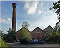
Former works, Old Road, Worcester
"The former City Electricity Works, 1893-94, by the City Engineer, S.G. Purchas (succeeded by Thomas Camk), with W.H. Preece as consultant. It was the first permanent hydroelectric power station built by any English municipality". Grade II* listed.
There is a close-up of the impressive octagonal chimney here Image
Converted to housing in 1999.
Image: © Stephen Richards
Taken: 17 Jul 2014
0.08 miles
10

Worcester's first power station
In front of the building is Powick Bridge that crosses the River Teme and was the site of a battle in the English Civil War. The building beyond with the impressive chimney was a combined hydroelectric and reciprocating steam engine power station. Unfortunately I only know the month this was taken, not the exact day. This building is now dwellings and the travelling crane from within is now preserved in front.
Image: © Chris Allen
Taken: Unknown
0.08 miles