IMAGES TAKEN NEAR TO
St. Michaels, TENBURY WELLS, WR15 8TG
Introduction
This page details the photographs taken nearby to WR15 8TG by members of the Geograph project.
The Geograph project started in 2005 with the aim of publishing, organising and preserving representative images for every square kilometre of Great Britain, Ireland and the Isle of Man.

There are currently over 7.5m images from over14,400 individuals and you can help contribute to the project by visiting https://www.geograph.org.uk
Image Map (Loading...)


Getting Data...Please wait
Leaflet Map data © OpenStreetMap
Images are licensed for reuse under creativecommons.org/licenses/by-sa/2.0
Notes
- Clicking on the map will re-center to the selected point.
- The higher the marker number, the further away the image location is from the centre of the postcode.
Image Listing (112 Images Found)
Images are licensed for reuse under creativecommons.org/licenses/by-sa/2.0
Image
Details
Distance
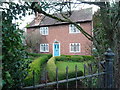
1
Cottage in St Michaels
Cottage in St Michaels with a garden of evergreen trees.
Image: © Philip Halling
Taken: 25 May 2017
0.05 miles
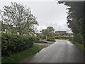
2
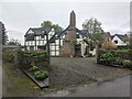
St. Michaels House
A nice timber-framed house on the country lane to Berrington. This looks like an old building, although it does not have listed status as of May 2024, and it was altered after it last appeared on the Google Maps street view in July 2016.
Image: © Fabian Musto
Taken: 3 May 2024
0.06 miles
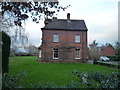
3

Drive to St. Michaels Farmhouse
The drive is on a public footpath and bridleway.
Image: © Fabian Musto
Taken: 3 May 2024
0.07 miles
4
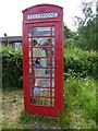
A beekeeper in a telephone box
Another redundant telephone box, unusually this one has a lifesize mannequin inside dressed as a beekeeper. Image] Different!
Image: © Philip Halling
Taken: 25 May 2017
0.07 miles
5
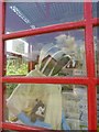
Very odd, a beekeeper in a phone box
Another redundant telephone box, unusually this one has a lifesize mannequin inside dressed as a beekeeper.
Image]
Image: © Philip Halling
Taken: 25 May 2017
0.07 miles
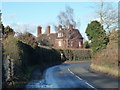
6
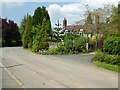
The village of St. Michaels
Viewed from the country lane adjacent to the village hall, with the grade II* listed parish church visible in the distance.
Image: © Fabian Musto
Taken: 3 May 2024
0.07 miles
7
Sunnycroft (St. Michael's)
A splendid decorated Georgian cottage by the A4112 road in St. Michael's. This is currently Grade II listed, and dates from the early 19th century.
Image: © Fabian Musto
Taken: 1 Dec 2018
0.13 miles
8
The Vicarage (St. Michael's)
I'm not sure if this vicarage is still used for the nearby church of St. Michael and All Angels or not. Anyways, this building dates from the Victorian times, and is placed near the A4112 road.
Image: © Fabian Musto
Taken: 10 Feb 2019
0.14 miles
9
The Vicarage (St. Michael's)
I'm not sure if this vicarage is still used for the nearby church of St. Michael and All Angels or not. Anyways, this building dates from the Victorian times, and is placed near the A4112 road.
Image: © Fabian Musto
Taken: 1 Dec 2018
0.15 miles
10
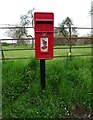
Elizabeth II postbox on the A4112, St Michaels
Postbox No. WR15 119.
Image: © JThomas
Taken: 17 Apr 2023
0.15 miles