IMAGES TAKEN NEAR TO
St. Michaels, TENBURY WELLS, WR15 8PJ
Introduction
This page details the photographs taken nearby to WR15 8PJ by members of the Geograph project.
The Geograph project started in 2005 with the aim of publishing, organising and preserving representative images for every square kilometre of Great Britain, Ireland and the Isle of Man.

There are currently over 7.5m images from over14,400 individuals and you can help contribute to the project by visiting https://www.geograph.org.uk
Image Map (Loading...)


Getting Data...Please wait
Leaflet Map data © OpenStreetMap
Images are licensed for reuse under creativecommons.org/licenses/by-sa/2.0
Notes
- Clicking on the map will re-center to the selected point.
- The higher the marker number, the further away the image location is from the centre of the postcode.
Image Listing (9 Images Found)
Images are licensed for reuse under creativecommons.org/licenses/by-sa/2.0
Image
Details
Distance
1
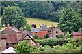
Harvested maize, Miles Hope.
Red soil exposed after forrage maize has been harvested. Below Raddle Bank, looking east.
Image: © Richard Webb
Taken: 6 Dec 2005
0.13 miles
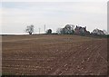
2
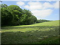
Farmland near Miles Hope
Farmland near Miles Hope just inside the county of Herefordshire.
Image: © Philip Halling
Taken: 25 May 2017
0.14 miles
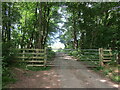
5
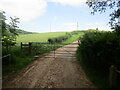
Gate on a lane from Wilden to the A4112
Image: © Jonathan Thacker
Taken: 2 Jun 2023
0.19 miles
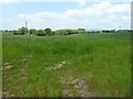
6
Field, Wilden
Taken while opening the gate on the road.
Image: © Richard Webb
Taken: 6 Apr 2014
0.19 miles
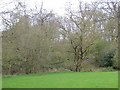
7
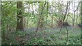
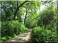
Woodland by Wilden
Taken while shutting the gate on the road.
Image: © Richard Webb
Taken: 2 May 2009
0.20 miles