IMAGES TAKEN NEAR TO
Eardiston, TENBURY WELLS, WR15 8JW
Introduction
This page details the photographs taken nearby to WR15 8JW by members of the Geograph project.
The Geograph project started in 2005 with the aim of publishing, organising and preserving representative images for every square kilometre of Great Britain, Ireland and the Isle of Man.

There are currently over 7.5m images from over14,400 individuals and you can help contribute to the project by visiting https://www.geograph.org.uk
Image Map
Images are licensed for reuse under creativecommons.org/licenses/by-sa/2.0
Notes
- Clicking on the map will re-center to the selected point.
- The higher the marker number, the further away the image location is from the centre of the postcode.
Image Listing (2 Images Found)
Images are licensed for reuse under creativecommons.org/licenses/by-sa/2.0
Image
Details
Distance
1
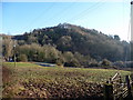
Menith Wood
Menith Wood is on the steep south facing slope of the Teme Valley. (View from near Dumbleton Farm). The Bridle way ascends steeply from the bridge see Image]to the hamlet of the same name.
Image: © Richard Greenwood
Taken: 3 Jan 2009
0.19 miles
2
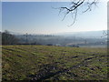
Teme Valley
Looking South east from above Dumbleton Farm
Image: © Richard Greenwood
Taken: 3 Jan 2009
0.21 miles