IMAGES TAKEN NEAR TO
Upper Teme Business Park, Clee Hill Road, TENBURY WELLS, WR15 8HB
Introduction
This page details the photographs taken nearby to Upper Teme Business Park, Clee Hill Road, WR15 8HB by members of the Geograph project.
The Geograph project started in 2005 with the aim of publishing, organising and preserving representative images for every square kilometre of Great Britain, Ireland and the Isle of Man.

There are currently over 7.5m images from over14,400 individuals and you can help contribute to the project by visiting https://www.geograph.org.uk
Image Map (Loading...)


Getting Data...Please wait
Leaflet Map data © OpenStreetMap
Images are licensed for reuse under creativecommons.org/licenses/by-sa/2.0
Notes
- Clicking on the map will re-center to the selected point.
- The higher the marker number, the further away the image location is from the centre of the postcode.
Image Listing (37 Images Found)
Images are licensed for reuse under creativecommons.org/licenses/by-sa/2.0
Image
Details
Distance
1
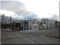
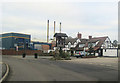
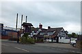
Kerry Ingredients Factory, Tenbury Wells
Produces sweet ingredients and flavourings, for the bakery, confectionery, ice-cream and dairy industries.
Image: © Roger Cornfoot
Taken: 26 Dec 2011
0.04 miles
2
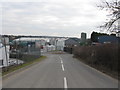
Tenbury Wells - Industrial Estate On Clee Hill Road
Image: © Peter Whatley
Taken: 9 Mar 2010
0.05 miles
3
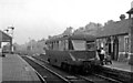
Tenbury Wells Station, with ex-Great Western Diesel railcar
View westward, towards Woofferton; ex-GWR Kidderminster - Woofferton line. No. 27 is one of the 1940 batch of Associated Equipment Co. (AEC) railcars first introduced in 1934: they proved very useful on the GWR for local services but were not to be perpetuated in Britain as railway passenger vehicles of general use for another 20 years.
Image: © Ben Brooksbank
Taken: 26 Aug 1949
0.06 miles
4
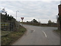
Tenbury Wells - Lane From Greete Meets Clee Hill Road
Image: © Peter Whatley
Taken: 9 Mar 2010
0.07 miles
5
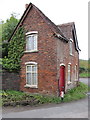
Old Toll House by Clee Hill Road, Burford
Toll House in the parish of Burford, Harp Bank or Signalman's Cottage, Clee Hill Road (B4214).
Grade II listed.
List Entry Number: 1383430 https://historicengland.org.uk/listing/the-list/list-entry/1383430
To be surveyed
Milestone Society National ID: SA.BUR02
Image: © Milestone Society
Taken: Unknown
0.07 miles
6
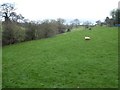
Valley off Clee Hill Road
Field in a valley to the west of Clee Hill Road at Burford.
Image: © Philip Halling
Taken: 29 Nov 2017
0.07 miles
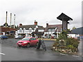
8
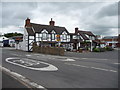
The Rose & Crown, Burford
Known locally as the Rosie I believe. Now surrounded by Kerry Ingredients large plant.
Image: © Jeremy Bolwell
Taken: 14 Aug 2012
0.10 miles
10
The Rose and Crown, Burford, Shropshire
Image: © Roger Cornfoot
Taken: 24 Oct 2009
0.11 miles