IMAGES TAKEN NEAR TO
St. Anns Road, MALVERN, WR14 4RG
Introduction
This page details the photographs taken nearby to St. Anns Road, WR14 4RG by members of the Geograph project.
The Geograph project started in 2005 with the aim of publishing, organising and preserving representative images for every square kilometre of Great Britain, Ireland and the Isle of Man.

There are currently over 7.5m images from over14,400 individuals and you can help contribute to the project by visiting https://www.geograph.org.uk
Image Map
Images are licensed for reuse under creativecommons.org/licenses/by-sa/2.0
Notes
- Clicking on the map will re-center to the selected point.
- The higher the marker number, the further away the image location is from the centre of the postcode.
Image Listing (1484 Images Found)
Images are licensed for reuse under creativecommons.org/licenses/by-sa/2.0
Image
Details
Distance
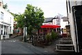
1
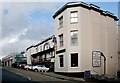
The Foley Arms
Looking up Worcester Road from near the Unicorn Pub.
Image: © Bob Embleton
Taken: 30 Sep 2006
0.00 miles
2
The Top of Edith Walk
HSBC (formerly Midland) Bank is on the left. The white building at the end on the right is Barclays Bank now, but built as a library in the early 1800s. The red building at the end (on Belle vue Terrace) is boarded up for redevelopment.
Edith Walk is the back road to the Church Street shops.
Image: © Bob Embleton
Taken: 2 Jan 2007
0.00 miles
3
Marston's Red Lion
A good pint to be had here!
Image: © Deborah Tilley
Taken: 22 Sep 2010
0.00 miles
4
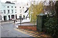
Lucy box, St Ann's Road, Malvern
Looking down St Anns Road to its junction with Worcester Road outside the timber framed Unicorn pub.
The green box on the right is known as a "Lucy box" - though this one (by its design and decoration) is probably made by Hardy & Padmore Ltd, Worcester and not by the Oxford company Lucy.
The boxes are usually associated with the distribution of electricity though some are thought to have been converted for telephone connections.
http://www.localhistory.scit.wlv.ac.uk/articles/lucy/lucyboxes2.htm
Image
Image
Image: © Bob Embleton
Taken: 18 Nov 2009
0.01 miles
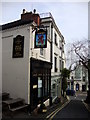
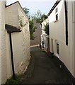
5
The Red Lion
Set back from St. Ann's Road just up from the Unicorn.
Image: © Bob Embleton
Taken: 2 Aug 2009
0.01 miles
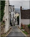
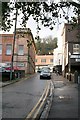
7
Red Lion Bank
One of the narrowest roads in Great Malvern.
Looking towards the junction with St. Ann's Road by the Red Lion pub.
Image: © Bob Embleton
Taken: 2 Aug 2009
0.01 miles
8
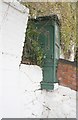
Lucy box, St Ann's Road, Malvern (rear)
Image: © Bob Embleton
Taken: 18 Nov 2009
0.01 miles
9

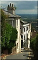
St Ann's Road, Malvern
St Ann's Road climbs away from the corner of the A449 Worcester Road,
towards St Ann's Knoll in the Malvern Hills. The Red Lion http://www.geograph.org.uk/photo/3933430 is ahead on the right.
Image: © Jaggery
Taken: 5 May 2013
0.01 miles
10
Listed buildings, St Ann's Road, Malvern
Upper Hill House https://historicengland.org.uk/listing/the-list/list-entry/1224105 and 2 St Ann's Road https://historicengland.org.uk/listing/the-list/list-entry/1266970 are the most prominent buildings.
Image: © Derek Harper
Taken: 13 Jul 2021
0.01 miles