IMAGES TAKEN NEAR TO
Westminster Bank, MALVERN, WR14 4BN
Introduction
This page details the photographs taken nearby to Westminster Bank, WR14 4BN by members of the Geograph project.
The Geograph project started in 2005 with the aim of publishing, organising and preserving representative images for every square kilometre of Great Britain, Ireland and the Isle of Man.

There are currently over 7.5m images from over14,400 individuals and you can help contribute to the project by visiting https://www.geograph.org.uk
Image Map
Images are licensed for reuse under creativecommons.org/licenses/by-sa/2.0
Notes
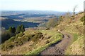
- Clicking on the map will re-center to the selected point.
- The higher the marker number, the further away the image location is from the centre of the postcode.
Image Listing (133 Images Found)
Images are licensed for reuse under creativecommons.org/licenses/by-sa/2.0
Image
Details
Distance
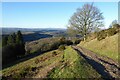
1
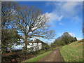
Track round the side of Table Hill
Leading to numerous other paths up, down and round the northern bit of the Malvern Hills.
Image: © Des Blenkinsopp
Taken: 10 Feb 2016
0.03 miles
2
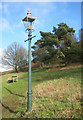
Gas Lamp on the Common
Gas lighting has been retained as a feature in the old parts of Malvern, although this one is unusually isolated.
Said to have been the inspiration behind author C S Lewis's inclusion of a gas lamp in his book "The Lion, The Witch and The Wardrobe"
Image: © Des Blenkinsopp
Taken: 10 Feb 2016
0.03 miles
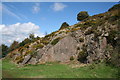
3
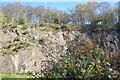
Gorse & Berries in a Quarry
Several large quarries used to operate near here. This was one of the smaller ones.
Image: © Des Blenkinsopp
Taken: 27 Oct 2024
0.05 miles
4
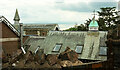
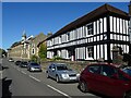
Regents Theological College, West Malvern
Part of the training centre of the Elim Pentecostal Church, seen from Westminster Bank, carrying the Sabrina Way.
Image: © Derek Harper
Taken: 13 Jul 2021
0.06 miles
5
Regents Theological College, West Malvern
Part of the training centre of the Elim Pentecostal Church. On the right, Westminster Bank (carrying the Sabrina Way) meets West Malvern Road.
Image: © Derek Harper
Taken: 13 Jul 2021
0.06 miles
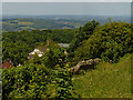
7
Path on Table Hill
Path on the eastern slopes of Table Hill at the northern end of the Malvern Hills. The Suckley Hills can be seen in the background.
Image: © Philip Halling
Taken: 16 Jan 2023
0.07 miles
8
Miniature Granite Quarry, Table Hill
A typical small quarry on the Malvern Hills. Probably to provide granite for nearby house construction or to make a path around the hills. The hills have been blighted by large scale granite quarries - all now, thankfully, stopped by the pressure of the Malvern Hills Conservators who keep the hills for the commoners and the general public to enjoy. Late September gorse brighten the scene - the broom flowers are long gone.
Image: © Bob Embleton
Taken: 24 Sep 2006
0.07 miles
9
Path on the western slopes of Table Hill
Path on the western slopes of Table Hill in the Malvern Hills. The Suckley Hills can be seen in the middle distance and the Clee Hills are on the horizon.
Image: © Philip Halling
Taken: 16 Jan 2023
0.07 miles
10
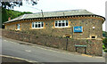
Elim International Centre
Elim International Centre buildings in West Malvern.
Image: © Philip Halling
Taken: 27 Sep 2020
0.07 miles