IMAGES TAKEN NEAR TO
Thirlstane Road, MALVERN, WR14 3PL
Introduction
This page details the photographs taken nearby to Thirlstane Road, WR14 3PL by members of the Geograph project.
The Geograph project started in 2005 with the aim of publishing, organising and preserving representative images for every square kilometre of Great Britain, Ireland and the Isle of Man.

There are currently over 7.5m images from over14,400 individuals and you can help contribute to the project by visiting https://www.geograph.org.uk
Image Map
Images are licensed for reuse under creativecommons.org/licenses/by-sa/2.0
Notes
- Clicking on the map will re-center to the selected point.
- The higher the marker number, the further away the image location is from the centre of the postcode.
Image Listing (241 Images Found)
Images are licensed for reuse under creativecommons.org/licenses/by-sa/2.0
Image
Details
Distance
1
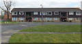
Thirlstane Road flats, Malvern
Located west of St Andrew's Road.
Image: © Jaggery
Taken: 5 May 2013
0.01 miles
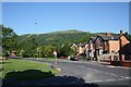
2
Thirlstane Road, Great Malvern
In the distance the road turns right, to pass under a railway bridge. In the background are the Malvern Hills.
Image: © P L Chadwick
Taken: 10 Jul 2011
0.02 miles
3
Thirlstane Road, Malvern
From its junction with St. Andrews Road near The Fountain.
The road passes beneath the Malvern to Ledbury railway line which is climbing its way to the tunnel through the Malvern Hills.
Worcestershire Beacon, the highest peak of the granite ridge provides a wonderful backdrop.
Image: © Bob Embleton
Taken: 30 May 2009
0.02 miles
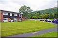
4
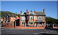
Houses on the corner of Court Road
Houses on the corner of Court Road and Thirlstan Road in Malvern. The building on the right used to Be the Fountain Inn.
Image: © Philip Halling
Taken: 23 Jan 2018
0.03 miles
5
The Fountain
Now Baxhill Fountain Nursery, but originally The Fountain Inn.
On the junction of St.Andrews Road and Thirlstane Road.
Image: © Bob Embleton
Taken: 30 May 2009
0.04 miles
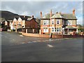
6
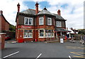
Fountain Stores, Malvern
On the corner of Thirlstane Road and Court Road. The building was formerly used as a children's nursery. The original use of the building is inscribed on the wall: The Fountain Inn.
Image: © Jaggery
Taken: 5 May 2013
0.04 miles
7

Fountain Stores
Originally a pub named the Fountain Inn, and onetime children's nursery on the corner of Thirlstane Road and Court Road. Today it is a shop named Fountain Stores. This building was photographed back in 2009 by Bob Embleton Image
Image: © Philip Halling
Taken: 1 Jan 2018
0.04 miles
8
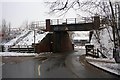
Railway bridge over Thirlstane Road
Carrying the Malvern to Hereford railway.
Image: © Bob Embleton
Taken: 5 Feb 2009
0.04 miles
9
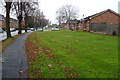
Bungalows on St Andrew's Road
Bungalows on St Andrew's Road in Malvern.
Image: © Philip Halling
Taken: 27 Nov 2018
0.04 miles
10
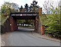
East side of Thirlstane Road railway bridge
The bridge carries the Cotswold Line railway. Headroom shown is 15' 0".
Image: © Jaggery
Taken: 5 May 2013
0.05 miles