IMAGES TAKEN NEAR TO
Albert Road North, MALVERN, WR14 2TP
Introduction
This page details the photographs taken nearby to Albert Road North, WR14 2TP by members of the Geograph project.
The Geograph project started in 2005 with the aim of publishing, organising and preserving representative images for every square kilometre of Great Britain, Ireland and the Isle of Man.

There are currently over 7.5m images from over14,400 individuals and you can help contribute to the project by visiting https://www.geograph.org.uk
Image Map (Loading...)


Getting Data...Please wait
Leaflet Map data © OpenStreetMap
Images are licensed for reuse under creativecommons.org/licenses/by-sa/2.0
Notes
- Clicking on the map will re-center to the selected point.
- The higher the marker number, the further away the image location is from the centre of the postcode.
Image Listing (62 Images Found)
Images are licensed for reuse under creativecommons.org/licenses/by-sa/2.0
Image
Details
Distance
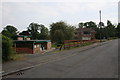
1
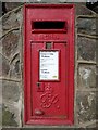
Georgian letterbox, Albert Road North
George V letterbox on the corner of Albert North Road and Sling Lane in Great Malvern.
Image: © Philip Halling
Taken: 27 Feb 2016
0.07 miles
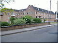
3
Renovated Montrose House
Renovated Montrose House on Graham Road in Malvern. I have photographed this building during refurbishment Image] Image
Image: © Philip Halling
Taken: 12 Sep 2019
0.08 miles
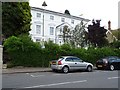
4
North-westerly end of Clerkenwell Crescent
Where Clerkenwell Crescent joins Cockshot Road.
Image: © Bob Embleton
Taken: 6 Dec 2009
0.09 miles
5
Malvern Police Station
Malvern Police Station on Victoria Road in Great Malvern.
Image: © Philip Halling
Taken: 5 Dec 2019
0.09 miles
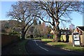
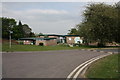
6
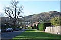
Sling Lane
Sling Lane runs down from Albert Road North to the railway line.
The routeway once continued under the railway bridge and on to Madresfield, though this is now limited to a footpath.
North Hill in the distance.
Image: © Bob Embleton
Taken: 6 Dec 2009
0.10 miles
7
Back Lane, Malvern
The lane runs along a level contour on the side of the Malvern Hills between the Worcester Road above and Graham Road below.
Originally providing services to the rear gardens of properties on the two main roads, it has now become the access road to houses built on the old gardens.
Photographed at its northern end where it meets Zetland Road.
The fat end of the lane emerges onto Edith Walk close to the new Waitrose supermarket.
Image: © Bob Embleton
Taken: 1 Sep 2011
0.11 miles
8
Mowbray Care Home
Mowbray Care Home on Victoria Road in Great Malvern.
Image: © Philip Halling
Taken: 5 Dec 2019
0.11 miles
9
Malvern Youth Centre and Malvern Hills College
The youth centre is under threat of destruction for the creation of housing.
Image: © Bob Embleton
Taken: 26 Apr 2011
0.15 miles
10
Malvern Youth Centre
Located next to Malvern Hills College.
Under threat of demolition to build houses.
Image: © Bob Embleton
Taken: 26 Apr 2011
0.15 miles