IMAGES TAKEN NEAR TO
Hayslan Green, MALVERN, WR14 2RG
Introduction
This page details the photographs taken nearby to Hayslan Green, WR14 2RG by members of the Geograph project.
The Geograph project started in 2005 with the aim of publishing, organising and preserving representative images for every square kilometre of Great Britain, Ireland and the Isle of Man.

There are currently over 7.5m images from over14,400 individuals and you can help contribute to the project by visiting https://www.geograph.org.uk
Image Map
Images are licensed for reuse under creativecommons.org/licenses/by-sa/2.0
Notes
- Clicking on the map will re-center to the selected point.
- The higher the marker number, the further away the image location is from the centre of the postcode.
Image Listing (49 Images Found)
Images are licensed for reuse under creativecommons.org/licenses/by-sa/2.0
Image
Details
Distance
1
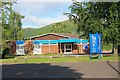
Malvern Evangelical Church
Located on Pickersleigh Road with North Hill as a backdrop.
Built around 1975 - we visited it during its construction.
http://www.mecmalvern.org.uk/index.php
Image: © Bob Embleton
Taken: 28 May 2009
0.06 miles
2
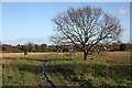
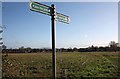
Path over Hayslan Field
The path takes one from Sling Lane to Hayslan Road.
Part of a longer route from Great Malvern to Madresfield.
This open space inside the urban environment may be lost under another housing estate in the next decade.
Image: © Bob Embleton
Taken: 6 Dec 2009
0.08 miles
3
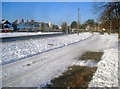
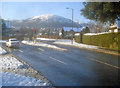
Snowy Pickersleigh Road
View from the passenger seat of a car awaiting to turn into Pickersleigh Road from North End Road.
Image: © Philip Halling
Taken: 20 Dec 2010
0.08 miles
4
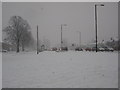
Pickersleigh Road
Main road on the left. Houses on this east side front onto a parallel road. In the foreground, a couple of 'prints' from cars which were parked here during the snow fall.
Image: © Trevor Rickard
Taken: 8 Jan 2010
0.09 miles
5
Hayslan Fields
One of several fields near the end of Hayslan Road.
This open space is crossed by several paths and, until recently, was a meadow enjoyed by the local population.
It has been designated as possible land for housing development and given the designation MHMT15 (Malvern Hills district council - Malvern Town 15).
Image: © Bob Embleton
Taken: 6 Dec 2009
0.09 miles
7
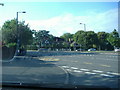
Junction of North End Lane with Pickersleigh Road
View west along North End Road with North Hill in the background. One of the busier junctions in Malvern.
Image: © Trevor Rickard
Taken: 8 Jan 2010
0.11 miles
8

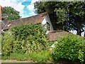
Pickersleigh Court, Great Malvern, Worcestershire
Pickersleigh Court is a grade II listed building in Malvern, Worcestershire.
Image: © Christine Matthews
Taken: 31 Aug 2013
0.11 miles
9

Pickersleigh Court, Great Malvern, Worcestershire
Pickersleigh Court is a grade II listed building in Malvern, Worcestershire.
Image: © Christine Matthews
Taken: 31 Aug 2013
0.11 miles
10
Pickersleigh Court, Great Malvern, Worcestershire
Pickersleigh Court is a grade II listed building in Malvern, Worcestershire.
Image: © Christine Matthews
Taken: 31 Aug 2013
0.11 miles