1
Blot on the Streetscape
If anything, this is even more inappropriate than
Image], not least because it can be seen from the hill above.
Image: © Anne Burgess
Taken: 9 May 2018
0.04 miles
2
Cotford Hotel
A Victorian pile of steep gables and carved eaves, now in use as a hotel.
Image: © Anne Burgess
Taken: 9 May 2018
0.04 miles
3
46 Worcester Road
https://historicengland.org.uk/listing/the-list/list-entry/1082725?section=official-list-entry
Image: © Sandy Gerrard
Taken: 1 May 2024
0.05 miles
4
A building on Worcester Road, Malvern
Image: © Ian S
Taken: 26 May 2014
0.05 miles
5
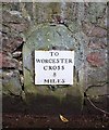
Milestone on the Worcester Road
To Worcester Cross 8 Miles.
The milestone has had a large Malvern granite wall built around it.
There is supposed to be a pivot bench mark on the top of the stone and the arrow mark is clearly visible, though the top is hidden by the wall.
There is, however, a horizontal mark on the wall above the stone.
The bench mark has been given the Waypoint number PV0146 on the bench mark database:-
http://www.bench-marks.org.uk/bm31278
Image: © Bob Embleton
Taken: 29 Mar 2010
0.05 miles
6
House on Worcester Road, Malvern
An early 19th century Grade II listed crenellated house with Gothick corner spires, on Worcester Road in Great Malvern.
Early C19, in the Gothick manner. Two storeys in stucco, battlemented, with
angle pilasters with trefoiled panels, crockets and finials. Three windows,
3-light mullion and transom casements with 4-centred lights and rectangular
dripmoulds. Centre breaks forward slightly and has angle pilasters with trefoiled panels. Moulded pointed-arch doorway, traceried panelling to door, ogee-arched dripmould with crockets and finial (Source:British Listed Buildings website),
Image: © Philip Halling
Taken: 3 Mar 2015
0.05 miles
7
Milestone on Worcester Rd, Malvern
Cut mark on top of the milestone and also on the wall above. These marks were used by Ordnance Survey for mapping purposes.
Image: © V1ncenze
Taken: 30 Sep 2019
0.06 miles
8
Old Milestone by the A449, Wells Road, Great Malvern
Metal plate attached to stone post by the A449, in parish of Malvern (Malvern Hills District), Wells Road, by No. 52; opposite Elm Bank Guest House, on the verge, on West side of road. Worcester Cross iron plate, erected by the Worcester turnpike trust in the 19th century.
Inscription reads:-
TO
WORCESTER
CROSS
8
MILES
Carved benchmark on top front.
Milestone Society National ID: WO_WOLB08
Image: © J Higgins
Taken: 1 Apr 2007
0.06 miles
9
Milestone on the Worcester Road
Looking northwards towards Link top and Malvern Link.
The milestone on the left ("To Worcester Cross 8 Miles") has a wall built around and over it.
Large, late 18th/early 19th century houses line the eastern side of the road.
A recent dropped kerb crossing point has been added on the side of the pavement allowing wheelchair users easier access to the opposite side of the road.
The bobbled surface of the light yellow surface is to assist visually impaired pedestrians to locate the crossing point.
Image
Image: © Bob Embleton
Taken: 29 Mar 2010
0.06 miles
10
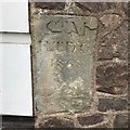
Old Boundary Marker
Parish Boundary Marker on the east side of the A449 Worcester Road, set in the front stone wall of number 49 Copsewood, butting on to a shop. Malvern parish. Inscribed G (?) M / I L D C (unclear) / 1868.Great Malvern Local Government District was formed in 1867. No map shows this as a boundary.
Milestone Society National ID: WO_MALV02pb
Image: © S Kosciow
Taken: 23 Jun 2020
0.06 miles


