1
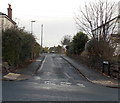
Jamaica Road, Malvern
Looking towards North Hill. The fields here were bought, hundreds of years ago, using profits from the estates in Jamaica. The name of the council house estate, built in the late 1940s, reflects this.
Image: © Bob Embleton
Taken: 17 Jan 2009
0.14 miles
2
Jamaica Road, Malvern
Looking north from Church Road.
Image: © Jaggery
Taken: 29 Nov 2014
0.15 miles
3
Jamaica Road, Malvern
The council housing estate was built in the late 1940s when very few people owned cars.
Image: © Bob Embleton
Taken: 17 Jan 2009
0.15 miles
4
The Malvern Hills from Goodwood Road crossing
A fine view from the footpath crossing of the Hereford-Worcester railway line.
Image: © Peter Whatley
Taken: 19 Apr 2021
0.18 miles
5
Playing field by the railway
A playing field at the rear of Jamaica Road, Malvern. The footpath from which the photo was taken involves a steep climb to railway level, but that is little disincentive to inquisitive children.
Image: © Peter Whatley
Taken: 19 Apr 2021
0.18 miles
6
Houses at Upper Howsell
Approaching Malvern Link Station
Image: © Julian P Guffogg
Taken: 9 Aug 2012
0.19 miles
7
Church Road houses, Malvern
On the north side of Church Road, between Upper Howsell Road and Jamaica Road http://www.geograph.org.uk/photo/4266720 (ahead).
Image: © Jaggery
Taken: 29 Nov 2014
0.19 miles
8
Somers Park Avenue Methodist Church
Somers Park Avenue Methodist Church was built in the 1930s and opened in 1936. The church hall can be seen to the left of the church.
Image: © Philip Halling
Taken: 25 Oct 2020
0.20 miles
9
Somers Park Methodist Church, Malvern Link
At the junction of Somers Park Avenue and Upper Howsell Road. Church on the right, hall on the left.
The church's website states that Somers Park Avenue Methodist Church had its beginnings in the 1880s with house groups meeting in Malvern Link. Numbers grew and by 1902 the land on which the present church stands was purchased. By 1906 enough funds had been raised to begin building work. In October 1907 the building on the left (now the hall) was opened. There were at the time only about 20 members. Though this number grew, the First World War saw setbacks. In the 1920s the church was thriving and had a large Sunday School, in 1928 over 150 pupils.
By 1930 it was decided that the new church envisaged by the first trustees should go ahead. With hard work and generous grants from the Methodist Church Connexion the new church opened in April 1936. In 1960-1961, further building work joined up the two main buildings and added a primary room, kitchen and toilets.
The church currently (2014) has a membership of 60+ with the number of adherents lifting the total to nearly 100. The church has a small but active Junior Church. It has a Ladies Club, house groups and regular games evenings. Each year at the end of August a very successful Holiday Club is held for a week. The church is active in Women's Network (raising money for World Missions), the Bible Society and other local ecumenical activities. Somers Park Avenue is also a Fair Trade Church.
Image: © Jaggery
Taken: 29 Nov 2014
0.20 miles
10
Jamaica Crescent, Malvern
Looking north from Church Road.
Image: © Jaggery
Taken: 29 Nov 2014
0.20 miles


