IMAGES TAKEN NEAR TO
Eastabrook Close, MALVERN, WR14 1TE
Introduction
This page details the photographs taken nearby to Eastabrook Close, WR14 1TE by members of the Geograph project.
The Geograph project started in 2005 with the aim of publishing, organising and preserving representative images for every square kilometre of Great Britain, Ireland and the Isle of Man.

There are currently over 7.5m images from over14,400 individuals and you can help contribute to the project by visiting https://www.geograph.org.uk
Image Map (Loading...)


Getting Data...Please wait
Leaflet Map data © OpenStreetMap
Images are licensed for reuse under creativecommons.org/licenses/by-sa/2.0
Notes
- Clicking on the map will re-center to the selected point.
- The higher the marker number, the further away the image location is from the centre of the postcode.
Image Listing (24 Images Found)
Images are licensed for reuse under creativecommons.org/licenses/by-sa/2.0
Image
Details
Distance
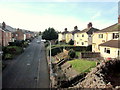
1
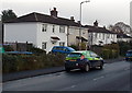
Jamaica Road, Malvern
The council housing estate was built in the late 1940s when very few people owned cars.
Image: © Bob Embleton
Taken: 17 Jan 2009
0.12 miles
2
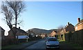
Jamaica Road, Malvern
Looking towards North Hill. The fields here were bought, hundreds of years ago, using profits from the estates in Jamaica. The name of the council house estate, built in the late 1940s, reflects this.
Image: © Bob Embleton
Taken: 17 Jan 2009
0.12 miles
3
Jamaica Road, Malvern
Looking north from Church Road.
Image: © Jaggery
Taken: 29 Nov 2014
0.14 miles
4
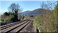
The Malvern Hills from Goodwood Road crossing
A fine view from the footpath crossing of the Hereford-Worcester railway line.
Image: © Peter Whatley
Taken: 19 Apr 2021
0.14 miles
5
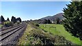
Playing field by the railway
A playing field at the rear of Jamaica Road, Malvern. The footpath from which the photo was taken involves a steep climb to railway level, but that is little disincentive to inquisitive children.
Image: © Peter Whatley
Taken: 19 Apr 2021
0.15 miles
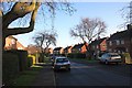
6
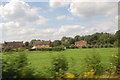
Houses at Upper Howsell
Approaching Malvern Link Station
Image: © Julian P Guffogg
Taken: 9 Aug 2012
0.17 miles
7
Jamaica Crescent, Malvern
Looking north from Church Road.
Image: © Jaggery
Taken: 29 Nov 2014
0.18 miles
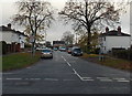
8
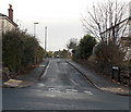
Church Road houses, Malvern
On the north side of Church Road, between Upper Howsell Road and Jamaica Road http://www.geograph.org.uk/photo/4266720 (ahead).
Image: © Jaggery
Taken: 29 Nov 2014
0.19 miles
9
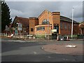
Somers Park Avenue Methodist Church
Somers Park Avenue Methodist Church was built in the 1930s and opened in 1936. The church hall can be seen to the left of the church.
Image: © Philip Halling
Taken: 25 Oct 2020
0.20 miles