IMAGES TAKEN NEAR TO
Redland Road, MALVERN, WR14 1LY
Introduction
This page details the photographs taken nearby to Redland Road, WR14 1LY by members of the Geograph project.
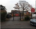
The Geograph project started in 2005 with the aim of publishing, organising and preserving representative images for every square kilometre of Great Britain, Ireland and the Isle of Man.

There are currently over 7.5m images from over14,400 individuals and you can help contribute to the project by visiting https://www.geograph.org.uk
Image Map (Loading...)


Getting Data...Please wait
Leaflet Map data © OpenStreetMap
Images are licensed for reuse under creativecommons.org/licenses/by-sa/2.0
Notes
- Clicking on the map will re-center to the selected point.
- The higher the marker number, the further away the image location is from the centre of the postcode.
Image Listing (238 Images Found)
Images are licensed for reuse under creativecommons.org/licenses/by-sa/2.0
Image
Details
Distance
1
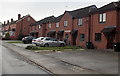
Cromwell Court, Malvern
Modern housing on the west side of Cromwell Road.
Image: © Jaggery
Taken: 29 Nov 2014
0.02 miles
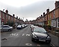
2
Redland Road, Malvern
Looking south from Church Road.
Image: © Jaggery
Taken: 29 Nov 2014
0.03 miles
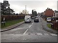
3
One-way system along Redland Road, Malvern Link
Two-way traffic along Redland Road behind the camera ends here, at the Cromwell Road junction.
Image: © Jaggery
Taken: 29 Nov 2014
0.03 miles
4
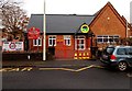
Main entrance to St Matthias C of E Primary School, Malvern Link
From Cromwell Road.
Image: © Jaggery
Taken: 29 Nov 2014
0.04 miles
5
Staff vehicles only entrance to St Matthias C of E Primary School, Malvern Link
From Redland Road into the NW corner of the school site.
The main school entrance is from Cromwell Road. http://www.geograph.org.uk/photo/4266950
Image: © Jaggery
Taken: 29 Nov 2014
0.05 miles
6
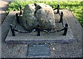
The Link Stone
Or Whore Stone on some old maps.
Now in the churchyard of St. Matthias, Malvern Link, but would have been one of several markers delineating the parish bounds.
Image
Image
Image: © Bob Embleton
Taken: 30 May 2009
0.05 miles
7
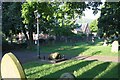
The Link Stone
In the churchyard of St Matthias, Malvern Link.
Image
Image: © Bob Embleton
Taken: 30 May 2009
0.05 miles
8
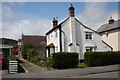
Field Cottage, Hampden Road, Malvern Link
Much older than the surrounding streets, this cottage is orthogonal to Hampden Road and sits on its own lane dating from when this was all fields.
Image: © Bob Embleton
Taken: 25 Jun 2011
0.06 miles
9
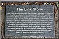
The Link Stone plaque
Attached to the Link stone in the churchyard of St. Matthias, Malvern Link.
Image
Image: © Bob Embleton
Taken: 30 May 2009
0.06 miles
10
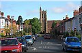
Hampden Road and St Matthias's Church
Viewed from the junction with Worcester Road in Malvern Link.
Image: © Bob Embleton
Taken: 28 May 2009
0.06 miles