IMAGES TAKEN NEAR TO
Back Lane South, WORCESTER, WR1 3DE
Introduction
This page details the photographs taken nearby to Back Lane South, WR1 3DE by members of the Geograph project.
The Geograph project started in 2005 with the aim of publishing, organising and preserving representative images for every square kilometre of Great Britain, Ireland and the Isle of Man.

There are currently over 7.5m images from over14,400 individuals and you can help contribute to the project by visiting https://www.geograph.org.uk
Image Map
Images are licensed for reuse under creativecommons.org/licenses/by-sa/2.0
Notes
- Clicking on the map will re-center to the selected point.
- The higher the marker number, the further away the image location is from the centre of the postcode.
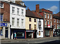
Image Listing (412 Images Found)
Images are licensed for reuse under creativecommons.org/licenses/by-sa/2.0
Image
Details
Distance
1

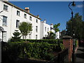
8-9 Britannia Square, Worcester
Albion House, perhaps the grandest pair in this upmarket Regency development. Grade II listed.
Image: © Stephen Richards
Taken: 15 Jul 2014
0.02 miles
2
Clinic, Moor Street, Worcester
An interestingly massed 1960s job. The filling is the interesting bit.
Operated by Worcestershire Health and Care NHS Trust.
Image: © Stephen Richards
Taken: 16 Jul 2014
0.04 miles
3
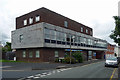
Britannia Square, Worcester
Brickwork and entrances located on Britannia Square, Worcester. The pillar outside number 17 is the location of an Ordnance Survey bench mark.
Image: © V1ncenze
Taken: 15 Jul 2020
0.05 miles
4
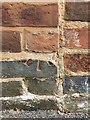
Ordnance Survey Bench Mark
This mark is located on a pillar outside number 17 Britannia Square, Worcester. The mark is damaged and only the lower part of the arrow remains. These marks were used by Ordnance Survey for mapping purposes.
Image: © V1ncenze
Taken: 15 Jul 2020
0.06 miles
5
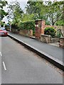
Britannia Square, Worcester
Britannia Square in Worcester has mainly large Georgian houses bordering the square.
Image: © Philip Halling
Taken: 1 Jul 2008
0.07 miles
6
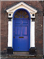
Detail of 34 The Tything, Worcester
A good late C18th Ionic doorcase.
Image: © Stephen Richards
Taken: 15 Jul 2014
0.07 miles
7
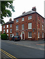
1-3 Love's Grove, Worcester
Late Georgian/early Victorian hipped-roof houses. Grade II listed.
No. 1 was offices of town planning consultants (since gone it seems), nos. 2-3 still residential.
Image: © Stephen Richards
Taken: 16 Jul 2014
0.07 miles
9
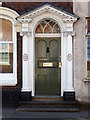
Detail of 26 The Tything, Worcester
Early C19th doorcase.
Wider view: Image
Image: © Stephen Richards
Taken: 15 Jul 2014
0.08 miles
10
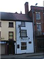
29-32 The Tything, Worcester
Moving out of town the Georgian houses tend to become humbler. The grander no. 29 on the right has a good doorcase (Image]). Grade II listed.
Next door, the single-bay no. 30, is the Lamb and Flag Inn, surely the snuggest pub in the city.
Image: © Stephen Richards
Taken: 17 Jul 2014
0.08 miles