IMAGES TAKEN NEAR TO
Infirmary Walk, WORCESTER, WR1 3AL
Introduction
This page details the photographs taken nearby to Infirmary Walk, WR1 3AL by members of the Geograph project.
The Geograph project started in 2005 with the aim of publishing, organising and preserving representative images for every square kilometre of Great Britain, Ireland and the Isle of Man.

There are currently over 7.5m images from over14,400 individuals and you can help contribute to the project by visiting https://www.geograph.org.uk
Image Map
Images are licensed for reuse under creativecommons.org/licenses/by-sa/2.0
Notes
- Clicking on the map will re-center to the selected point.
- The higher the marker number, the further away the image location is from the centre of the postcode.
Image Listing (2127 Images Found)
Images are licensed for reuse under creativecommons.org/licenses/by-sa/2.0
Image
Details
Distance
1
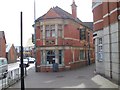
The Paul Pry
A CAMRA listed free house which is a listed building - http://www.britishlistedbuildings.co.uk/en-489153-the-paul-pry-public-house-and-attached-r
Image: © Stephen Rogerson
Taken: 11 Jun 2014
0.01 miles
2
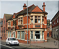
The Paul Pry, The Butts, Worcester
This pub building is a little work of art, built in 1901, the guiding hand Frederic Hughes. Grade II listed.
Image: © Stephen Richards
Taken: 16 Jul 2014
0.01 miles
3
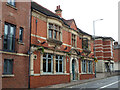
The Paul Pry public house, Worcester
Named after a popular theatrical character of the time this a well preserved late-Victorian public house. I believe I had a pint in there one Saturday before Covid-19 struck.
Image: © Chris Allen
Taken: 16 Aug 2021
0.01 miles
4
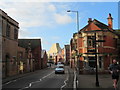
The Paul Pry on The Butts, Worcester
With The Hive (the golden building), Europe's first joint university and public library.
Image: © Jeff Gogarty
Taken: 3 Jan 2020
0.01 miles
5
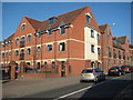
Apartments on The Butts
In recent years this area of Worcester has undergone considerable redevelopment including these apartments on The Butts.
Image: © Philip Halling
Taken: 4 Mar 2011
0.02 miles
6
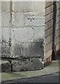
Bench mark, Angel Place
See http://www.geograph.org.uk/photo/4855665 for location.
Image: © Alan Murray-Rust
Taken: 5 Mar 2016
0.02 miles
7
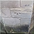
Ordnance Survey Cut Mark
This OS cut mark can be found on the building at the junction of Angel Place and The Butts. It marks a point 22.1590m above mean sea level.
Image: © Adrian Dust
Taken: 21 Jan 2019
0.02 miles
9
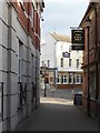
Alleyway passing The Paul Pry
Alleyway passing The Paul Pry off The Butts in Worcester.
Image: © Philip Halling
Taken: 4 Feb 2016
0.02 miles
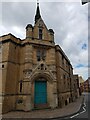
10
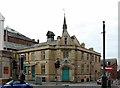
The Angel Centre
Built in 1887-8 by Aston Webb as the Sunday School for the adjacent Congregational Church, now a community centre and music venue. Listed Grade II.
There is a bench mark http://www.geograph.org.uk/photo/4855660 just to the right of the main door.
Image: © Alan Murray-Rust
Taken: 5 Mar 2016
0.02 miles