IMAGES TAKEN NEAR TO
Shelsley Drive, MALVERN, WR13 6PS
Introduction
This page details the photographs taken nearby to Shelsley Drive, WR13 6PS by members of the Geograph project.
The Geograph project started in 2005 with the aim of publishing, organising and preserving representative images for every square kilometre of Great Britain, Ireland and the Isle of Man.

There are currently over 7.5m images from over14,400 individuals and you can help contribute to the project by visiting https://www.geograph.org.uk
Image Map
Images are licensed for reuse under creativecommons.org/licenses/by-sa/2.0
Notes
- Clicking on the map will re-center to the selected point.
- The higher the marker number, the further away the image location is from the centre of the postcode.
Image Listing (90 Images Found)
Images are licensed for reuse under creativecommons.org/licenses/by-sa/2.0
Image
Details
Distance
1
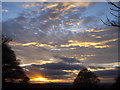
Sunset west of the Malverns (2)
From the car park at Upper Colwall.
Image: © Trevor Rickard
Taken: 1 Nov 2007
0.03 miles
2
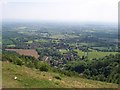
Upper Colwall from the Malvern Hills path
Image: © Andrew King
Taken: 3 Jun 2010
0.06 miles
3
Railway tunnel air shaft, Upper Colwall, Malverns
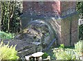
The original railway tunnel beneath the Malvern Hills connecting Hereford to Worcester was completed in 1861. After a partial roof collapse in 1907 a new tunnel was planned to run alongside the old. This was completed in 1926. This air shaft bears the date 1910 and appears to be built above the old tunnel, but has a connection, near ground level to what may be the new tunnel.
Image]
Image]
Image: © Bob Embleton
Taken: 14 Apr 2014
0.08 miles
4
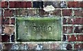
Railway tunnel air-shaft date stone 1910, Upper Colwall
The roof of the tunnel partially collapsed in 1907.
It is said to have been near one of the air shafts - perhaps this one - as this was built soon after that date.
Image]
Image]
Image: © Bob Embleton
Taken: 14 Apr 2014
0.08 miles
5
Base of railway tunnel airshaft, Upper Colwall
The first railway tunnel through the Malvern Hills suffered a partial roof collapse in 1907.
This air shaft bears the date 1910.
A new tunnel running parallel was then started and opened in 1926.
It appears a link from the new air shaft to the tower over the old tunnel has been made.
Image]
Image]
Image: © Bob Embleton
Taken: 14 Apr 2014
0.08 miles
6
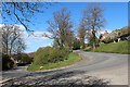
Hairpin bend Upper Colwall
On the B4218 climbing up the west side of the Malvern Hills from Colwall Stone to pass through the Wyche Cutting to Great Malvern.
Beneath the feet of the photographer are the two railway tunnels to connect Hereford to Worcester.
The older tunnel was opened in 1861 but following a partial roof collapse in 1907 a new tunnel was started.
The second tunnel was opened in 1926.
Image: © Bob Embleton
Taken: 14 Apr 2014
0.09 miles
7
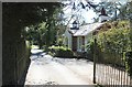
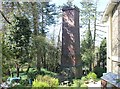
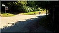
Gate house and driveway to Linden Manor
One of two gate houses either side of the road erected by the engineer Stephen Ballard who built the railway tunnel through the Malvern Hills.
Image: © Bob Embleton
Taken: 14 Apr 2014
0.09 miles
8
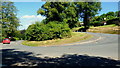
Sweeping curve
The B4218 descending the east side of The Wyche via switchbacks like this one.
Image: © Jonathan Billinger
Taken: 17 Jul 2014
0.09 miles

10
Chase Road, north end
A lady is proceeding at her own pace towards the bus stop.
Image: © Jonathan Billinger
Taken: 17 Jul 2014
0.10 miles