IMAGES TAKEN NEAR TO
Penny Lane, MALVERN, WR13 6PG
Introduction
This page details the photographs taken nearby to Penny Lane, WR13 6PG by members of the Geograph project.
The Geograph project started in 2005 with the aim of publishing, organising and preserving representative images for every square kilometre of Great Britain, Ireland and the Isle of Man.

There are currently over 7.5m images from over14,400 individuals and you can help contribute to the project by visiting https://www.geograph.org.uk
Image Map
Images are licensed for reuse under creativecommons.org/licenses/by-sa/2.0
Notes
- Clicking on the map will re-center to the selected point.
- The higher the marker number, the further away the image location is from the centre of the postcode.
Image Listing (46 Images Found)
Images are licensed for reuse under creativecommons.org/licenses/by-sa/2.0
Image
Details
Distance
1
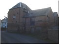
Malthouse at Guarlford
The old malthouse was built in 1870. By 1911 all malt production had ceased and the building was left vacant. In 1922 it became the premises of the newly formed Guarlford Parish Club, then the Guarlford Men's Club (the sign is still there on the right). Today it is unoccupied again except for the village hall, which uses part of the building.
Image: © Trevor Rickard
Taken: 19 Dec 2007
0.01 miles
2
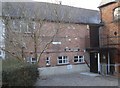
Guarlford Village Hall
Unusual to see a village hall which is part of a row of buildings. The disused men's club is to the right. Guarlford has an interesting web site...
http://www.guarlford.org.uk/hall_trustees.htm
Image: © Trevor Rickard
Taken: 19 Dec 2007
0.02 miles
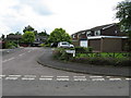
3
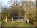
Gateway to Guarlford
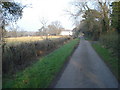
Through the gate the short track leads to the village at the far end.
Image: © Trevor Rickard
Taken: 19 Dec 2007
0.03 miles
4
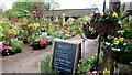
Grange Farm Nurseries
A small independent plant centre that has an enviable reputation for quality.
Image: © Jonathan Billinger
Taken: 19 May 2012
0.03 miles
6
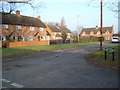
Penny Close
Horseshoe-shaped set of houses in the centre of Guarlford.
Image: © Trevor Rickard
Taken: 19 Dec 2007
0.04 miles
7
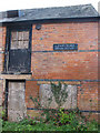
Disused malthouse, Guarlford
Built in 1870 and last used for malt production in 1911. See also Image The building still bears the sign for the Guarlford Men's Club.
Image: © Pauline E
Taken: 2 Nov 2009
0.04 miles
8
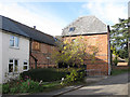
Guarlford Village Hall
Using part of the former malthouse, built in 1870 and last used for its intended purpose in 1911. The building stood vacant for a while then was used by the 'Parish Club' followed by the 'Guarlford Men's Club'
Image: © Pauline E
Taken: 2 Nov 2009
0.04 miles
9
Lane to Guarlford
View north-east along the lane from Woodbridge Farm.
Image: © Trevor Rickard
Taken: 19 Dec 2007
0.04 miles
10
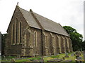
St Mary's church, Guarlford
Guarlford church is situated on the side of the B4211.
Image: © Philip Halling
Taken: 20 May 2008
0.04 miles