IMAGES TAKEN NEAR TO
Jennet Tree Lane, MALVERN, WR13 5BE
Introduction
This page details the photographs taken nearby to Jennet Tree Lane, WR13 5BE by members of the Geograph project.
The Geograph project started in 2005 with the aim of publishing, organising and preserving representative images for every square kilometre of Great Britain, Ireland and the Isle of Man.

There are currently over 7.5m images from over14,400 individuals and you can help contribute to the project by visiting https://www.geograph.org.uk
Image Map (Loading...)


Getting Data...Please wait
Leaflet Map data © OpenStreetMap
Images are licensed for reuse under creativecommons.org/licenses/by-sa/2.0
Notes
- Clicking on the map will re-center to the selected point.
- The higher the marker number, the further away the image location is from the centre of the postcode.
Image Listing (19 Images Found)
Images are licensed for reuse under creativecommons.org/licenses/by-sa/2.0
Image
Details
Distance
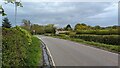
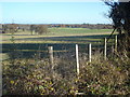
1
Footpath sign
Indicating a public path that no-one seems to want to use; see Image
Image: © Jonathan Billinger
Taken: 24 Jun 2015
0.02 miles
2
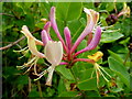
Wild honeysuckle
Close-up of the Lonicera sp. shown in context in Image
Image: © Jonathan Billinger
Taken: 24 Jun 2015
0.03 miles
3
Wild honeysuckle by a gatepost
Lonicera sp. growing wild by Jennett Tree Lane.
Image: © Jonathan Billinger
Taken: 24 Jun 2015
0.03 miles
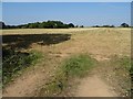
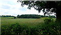
4
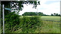
Non-existent path off Jennett Tree Lane
The path should cross this arable field to the wood in the distance but there is no sign of foot passage; presumably the few folks who have tried this recently have turned right and used the headland.
Image: © Jonathan Billinger
Taken: 24 Jun 2015
0.04 miles
5
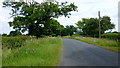
Jennett Tree Lane
Heading towards Deblin's Green and Callow.
Image: © Jonathan Billinger
Taken: 24 Jun 2015
0.06 miles
6
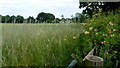
Stubble field
Stubble field beside Genetree Lane.
Image: © Philip Halling
Taken: 20 Sep 2020
0.08 miles
7
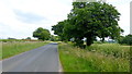
Jennett Tree Lane
The road from Madresfield to Callow winds through pleasant Worcestershire countryside.
Image: © Jonathan Billinger
Taken: 24 Jun 2015
0.12 miles
9
Sheep pasture at Upper Woodsfield Farm
View north-east from the lane over extensive pasture land. Worcester in the distance.
Image: © Trevor Rickard
Taken: 29 Nov 2007
0.14 miles
10
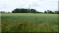
Woodsfield; fields and woods
Countryside south of Jennett Tree Lane.
Image: © Jonathan Billinger
Taken: 24 Jun 2015
0.15 miles