IMAGES TAKEN NEAR TO
Barnard Crescent, BROADWAY, WR12 7ES
Introduction
This page details the photographs taken nearby to Barnard Crescent, WR12 7ES by members of the Geograph project.
The Geograph project started in 2005 with the aim of publishing, organising and preserving representative images for every square kilometre of Great Britain, Ireland and the Isle of Man.

There are currently over 7.5m images from over14,400 individuals and you can help contribute to the project by visiting https://www.geograph.org.uk
Image Map (Loading...)


Getting Data...Please wait
Leaflet Map data © OpenStreetMap
Images are licensed for reuse under creativecommons.org/licenses/by-sa/2.0
Notes
- Clicking on the map will re-center to the selected point.
- The higher the marker number, the further away the image location is from the centre of the postcode.
Image Listing (58 Images Found)
Images are licensed for reuse under creativecommons.org/licenses/by-sa/2.0
Image
Details
Distance
1
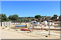
Building More Broadway
Part of a sizeable construction site north of the town.
Image: © Des Blenkinsopp
Taken: 26 Jun 2018
0.01 miles
2
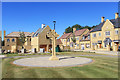
Celtic Cross and New Houses
A large estate of new housing is going up along Leamington Road on the north side of Broadway.
Image: © Des Blenkinsopp
Taken: 26 Jun 2018
0.06 miles
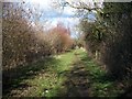
3
![Broadway footpath [7]](https://s1.geograph.org.uk/geophotos/01/72/18/1721893_ad4efc0c_120x120.jpg)
Broadway footpath [7]
Broadway has many, many footpaths criss-crossing the village, not all of which are shown on the 1:50,000 OS map. They are little used and little seen by the casual visitor. This path started at the High Street and has followed a sinuous route to this point where it finally emerges into open fields.
Image: © Michael Dibb
Taken: 10 Feb 2010
0.07 miles
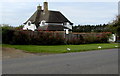
4
Footpath to Willersey
The path here passes through some recent plantings.
Image: © Michael Dibb
Taken: 10 Feb 2010
0.10 miles
5
Sandscroft B&B, Broadway
Guesthouse set back from Leamington Road at the northern edge of the village.
Image: © Jaggery
Taken: 1 May 2016
0.11 miles
6
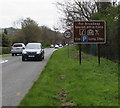
Broadway tourist attractions brown sign, Broadway
Facing Leamington Road at the northern edge of the Worcestershire village.
Image: © Jaggery
Taken: 1 May 2016
0.12 miles
7
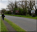
Walking towards Broadway
The walker on the Leamington Road pavement is near the Broadway boundary
sign http://www.geograph.org.uk/photo/5243621 on the right at the northern edge of the Worcestershire village.
Image: © Jaggery
Taken: 1 May 2016
0.12 miles
8
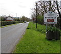
Welcome to Broadway Historic Cotswold village, Worcestershire
The sign is alongside Leamington Road at the northern edge of the village.
Image: © Jaggery
Taken: 1 May 2016
0.12 miles
9
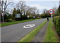
End of the 30 zone at the northern edge of Broadway
The 30mph speed limit on Leamington Road increases to 40mph.
Image: © Jaggery
Taken: 1 May 2016
0.12 miles
10
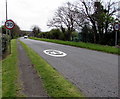
Start of the 30 zone at the northern edge of Broadway
The 40mph speed limit on Leamington Road drops to 30mph.
Image: © Jaggery
Taken: 1 May 2016
0.12 miles